History of Nova Scotia
with special attention given to
Communications and Transportation
Chapter 2
1 January 1700 to 31 December 1769
Go To: Index with links to the other chapters
1702 March 8 (OS)
1702 March 19 (NS)
Queen Anne
Born in 1665, Anne, was the younger daughter of James VII and II by his first wife, Anne Hyde. Anne inherited the British throne on 8 March 1702 (OS) 19 March 1702 (NS) when her brother-in-law, King William of Orange, died of complications after he was thrown from his horse and broke his collarbone. She became Queen of England, Scotland, and Ireland (1702-1707), later Queen of Great Britain and Ireland (1707-1714). The last Stuart ruler, Anne was the first to rule over Great Britain, which was created when the Act of Union joined Scotland to England and Wales in 1707. Her reign, like that of William III, was one of transition to parliamentary government; Anne was, for example, the last English monarch to exercise (1707) the royal veto. Domestic and foreign affairs alike were dominated by the War of the Spanish Succession, known in America as Queen Anne's War.
References:
History of the Scottish Crown
http://www.royal.gov.uk/history/scotland/stewart.htm
Queen Anne
http://www.royal.gov.uk/history/scotland/stewart.htm#ANNE
Queen Anne
http://infoplease.lycos.com/ce6/people/A0804118.html
Queen Anne's War / War of the Spanish Succession, 1702-1713
http://www.usahistory.com/wars/spansucc.htm
Those dates — 1702 March 8 (OS) and 1702 March 19 (NS) — are actually the same day, even though they appear at first to be eleven days apart. The OS (Old Style) date is stated in the Julian calendar, and the NS (New Style) date is stated in the Gregorian calendar. (For a more detailed explanation, see some of the websites referenced below.)
There is another complication that arises from the fact that, before 1707, Scotland and England were separate and independent countries, with separate governments and separate legal systems which often did things differently (and still do). In 1600, Scotland adopted the Gregorian calendar — sort of — and Scottish history records dates after 1600 as NS dates. However, England continued to use the Julian calendar until 1752. Thus, dates from 1600 to 1752 are recorded in English history as OS dates but in Scottish history as NS dates. After the death of Queen Elizabeth in March 1603 the two countries had the same person as King, and such events as the death of King James VI/I were recorded in two different calendars in the two countries. (Many historians simply ignore these calendar intricacies, and use OS and NS dates as if they were interchangeable. This approach is often satisfactory, given the slowness of long-distance communications in those days.)
Through the Middle Ages various New Year dates were used at various times for various purposes. If an ancient document refers to year YYYY, it may mean any of seven different periods in our present calendar:
1 Mar YYYY to 28/29 Feb YYYY+1
1 Jan YYYY to 31 Dec YYYY
1 Jan YYYY-1 to 31 Dec YYYY-1
25 Mar YYYY-1 to 24 Mar YYYY
25 Mar YYYY to 24 Mar YYYY+1
Saturday before Easter YYYY to Friday before Easter YYYY+1
25 Dec YYYY-1 to 24 Dec YYYY
Choosing the right interpretation of a year number isn't always easy, and it becomes more difficult in those cases where one country might use two different systems for religious and civil purposes — and there are examples of a single country at one time using three different calendars with three different New Year dates, for civil, legal, and religious purposes. When such multiple calendars were in use, many records fail to state which dating system was used for a particular document (it being assumed, I suppose, that everyone was familiar with the appropriate interpretation and it wasn't necessary to state the details in every document, which no doubt was true at the time but less so centuries later).
That phrase: "one country might use different systems for religious and civil purposes" has an archaic quality that can seem applicable only to places long ago and far away. However, this description applies to Canada in 2002 – at least to certain regions in the western provinces, and in Cape Breton. Every year, early in January, a story is distributed by the Canadian newswire services and carried in newspapers and electronic media about certain churches celebrating Christmas on January 6th. These media reports rarely explain that these churches are celebrating Christmas on December 25th, but are using a traditional calendar different from that used for ordinary civil purposes.
The Internet now provides several websites with good information about various calendars. Some useful references:
Calendars — This information is reprinted from the Explanatory Supplement to the Astronomical Almanac, P. Kenneth Seidelmann, editor
http://charon.nmsu.edu/~lhuber/leaphist.html
Old Style and New Style Dates and the Change to the Gregorian Calendar
http://www.genfair.com/dates.htm
Calendar Studies
http://serendipity.magnet.ch/hermetic/cal_stud.htm
Calendar FAQ
http://www.pauahtun.org/CalendarFAQ/cal/node1.html
Eleven Days that Never Were: The Curious History of the Gregorian Calendar
http://www.infoplease.com/spot/gregorian1.html
http://www.factmonster.com/spot/gregorian1.html
Gregorian Calendar
http://es.rice.edu/ES/humsoc/Galileo/Things/gregorian_calendar.html
Julian - Gregorian Calendar Change (Part I)
http://sites.netscape.net/chrislintzen/JULIAN.htm
Julian - Gregorian Calendar Change (Part II)
http://sites.netscape.net/chrislintzen/GREGORIAN.htm
Gregorian Calendar
http://sunsite.ualberta.ca/Documentation/Gnu/gcal-2.40/html_chapter/gcal_5.html
About Time — Mainly Calendars
http://www.greenheart.com/billh/intro.html
Gregorian Calendar
http://www.treasure-troves.com/astro/GregorianCalendar.html
The Gregorian Calendar
http://www.math.sfu.ca/histmath/calendars/gregorian.html
The British Switch to the Gregorian Calendar
http://www.crowl.org/Lawrence/time/britgreg.html
Astronomical Calendars
http://www.maa.mhn.de/Scholar/calendar.html
|
1707 May
Creation of Great Britain
In London the English Parliament passed the Act of Succession. This offered Britain's throne to the Hanovarians, declared war on France and chose who would be Scotland's commissioners in Union treaties, all without proper consultation or representation of the Scottish Parliament.
When Scotland rejected English rulings further financial pressures were applied, and when compensation for shareholders hurt by the Darien collapse was offered in return for accepting Parliamentary Union, treaties began to be drawn up.
To the powerful who would gain this was talked of as finance due to the country, but for the ordinary people this was simple political bribery to purchase their independence. John Campbell, 2nd Duke of Argyll and James Douglas, 2nd Duke of Queensberry represented the government and manipulated parliamentary debates into an environment of Member's personal interests.
The Union was agreed and the commissioners for Scotland chosen by the Queen.
The resulting treaty of twenty five articles retained the independence of Scotland's legal and religious systems, while systems of coinage, taxation, sovereignty, trade, parliament and flag would become one.
The first article was accepted in Edinburgh in November 1706 and the last in January 1707. Scotland's Parliament was dissolved in April 1707 and independence was over.
The Union began in May 1707.
Source: The Act of Union 1707
http://www.scotclans.com/clans/1707.htm
1713 March 31 (OS)
1713 April 11 (NS)
Treaty of Utrecht
The Treaty of Utrecht, signed March 31 (OS), April 11 (NS), 1713, gave Acadia (modern Nova Scotia and New Brunswick) to Britain while France kept Ile Royale (Cape Breton Island) and Ile St-Jean (Prince Edward Island).
Sources:
The National Post, 31 March 2000
and http://sites.internetcorp.net/~mcferran/utrecht.htm
"OS" means Old Style (Julian Calendar).
"NS" means New Style (Gregorian Calendar).
|
References:
The Treaty of Utrecht, Article 13: The Island called Newfoundland...
http://www.heritage.nf.ca/exploration/utrecht.html
http://collections.ic.gc.ca/placentia/troutr.htm
Selected Articles from the Treaty of Utrecht
http://sites.internetcorp.net/~mcferran/utrecht.htm
Dates in Six Nations History
http://www.landclaimsdocs.com/snlr/1700s.htm
As a result of the Treaty of Utrecht, in 1713, Acadia was surrendered to the English; however, the territorial boundaries of "Acadia" would remain in question for another fifty years. English authorities asserted the entire region from the Kennebec River to the Saint Lawrence (including present-day Nova Scotia, New Brunswick, Maine, and southeast Quebec) as an English possession; while French authorities claimed that lands north of the Bay of Fundy (present-day New Brunswick) had not been surrendered under the treaty and was therefore French territory...
http://www.gov.nb.ca/culture/heritage/histlives/1713.html
Queen Anne's War / War of the Spanish Succession, 1702-1713
http://www.usahistory.com/wars/spansucc.htm
French v. English Domination of North America
http://collections.ic.gc.ca/acadian/english/eexile/table/table.htm
British Empire18th Century Timeline
http://www.edunltd.com/empire/timeline/18century.htm
Origin of the Legal Title to the North American colonies
http://www.constitution.org/js/js_101.txt
The Context of the Renunciations of 1713
http://www.heraldica.org/topics/france/utrecht-a.htm
The Treaties of Utrecht between France and Great Britain, Spain and Great Britain, and the Netherlands and France of 1713, and between Spain and the Netherlands of 1714; the Treaties of Baden/Rastätt of 1714 between Louis XIV of France and Holy Roman Emperor Charles VI; the Treaty of the Hague between France, Great Britain and the United Provinces of the Netherlands of 1714; the Treaty, or Quadruple Alliance of London between France, Great Britain, the Emperor and Savoy (in lieu of the United Provinces of the Netherlands who withdrew at the last minute) of 1718; the Treaty of the Hague between Spain and the Emperor of 1720; and the Treaty of Vienna between Spain and the Emperor of 1725; were each intended to settle the conflicting claims resulting from the fourteen-year conflict known as the War of the Spanish Succession, which was fought in Europe, on the high seas, and in North America (where it was known as Queen Anne's War). Each of them included renunciations by the various parties of claims on territories and of rights to future successions, almost all of which were honoured more in the breach than in their execution...
http://www.chivalricorders.org/royalty/bourbon/france/success/sucprt1.htm
Treaty of Utrecht (London: House of Commons, Hansard, 12 July 1999)
Q: Dr. Marek: To ask the Secretary of State for Foreign and Commonwealth Affairs if it is the Government's policy to abide by all the provisions of the Treaty of Utrecht.
A: Ms Quin: The agreement signed in 1713 and known as the Treaty of Utrecht was part of a series of treaties which ended the War of the Spanish Succession. The full Treaty contained provisions relating to a wide range of areas and issues, many of which are no longer applicable. British title to the Rock of Gibraltar is based on Article X of the Treaty. In determining title to the Rock, this remains binding under international law upon the two parties, the UK and Spain. Both parties have so conducted themselves for many years.
http://www.parliament.the-stationery-office.co.uk/pa/cm199899/cmhansrd/
cm990712/text/90712w16.htm
Also
http://www.parliament.the-stationery-office.co.uk/pa/cm199899/cmselect/
cmfaff/366/36610.htm
Treaty Signed Between Great Britain and Spain at Utrecht on 13th July 1713
http://www.self-determination.gi/treaty_signed_between_great_brit.htm
http://www.frontier.gibnet.gi/laws/utrecht.html
"A thoroughly abhorrent Treaty..."
http://www.self-determination.gi/un_decolonisation_committee.htm
1719 March 7
Construction of the Fortress of Louisbourg
On this day, Michel-Philippe Isabeau began construction of the fortress at Louisbourg on Cape Breton Island.
[The National Post, 7 March 2000]
1724
Earliest Export of Minerals
The first officially recorded export of minerals from the territory now known as Canada occurred in 1724, when a load of coal was shipped from Cape Breton to Boston.
[The Halifax Chronicle-Herald 14 September 1999]
1725 August 27
Le Chameau Wrecked
On this day, in a storm off the north-eastern corner of Cape Breton, while trying to make the mouth of Louisbourg harbour, Le Chameau, a French man-of-war was driven in upon the hard rocky shore with the result that all 316 persons aboard perished. Le Chameau was a 48 gun, 600 ton, French man-of-war, the pride of the French navy, one of the fastest and best equipped line-of-battle ships in the royal navy of France. Le Chameau was employed to bring from France supplies and people to both Quebec and Louisbourg. For instance, during a busy four year period, beginning in 1721, when the French were pouring supplies and men into Louisbourg, Le Chameau was making annual runs...
Source:
Peter Landry's "The Loss of Le Chameau" at
http://www.blupete.com/Hist/Gloss/Chameau.htm
1725 August 26 (O.S.)
The Territory of the Colony of Massachusetts
The Province of the Massachusetts Bay in New England
included the territories now known as Maine, New Brunswick, and Nova Scotia
GEORGE BY THE GRACE OF GOD of Great Britain France and Ireland king Defender of the Faith &c To all to whom these Presents shall come Greeting Whereas Our late Royal Predecessors William and Mary King and Queen of England &c Did by their letters Patents under their Great Seal of England bearing Date at Westminster the Seventh day of October in the Third year of their Reign for themselves their Heires and Successors Vnite Erect and Incorporate the Territories and Colonies commonly called or known by the Names of the Colony of the Massachusetts Bay and Colony of New Plymouth the Province of Main the Territory called Accada or Nova Scotia and all that Tract of land lying between the said Territorys of Nova Scotia and the said Province of Main into One Reall Province by the Name of Our Province of the Massachusetts Bay in New England ... In witness whereof Wee have Caused these Our letters to be made Patents Witness William Archbishop of Canterbury and the rest of the Guardians and Justices of the Kingdom at Westminster the Six and twentieth day of August in the twelfth year of Our Reign
Source:
Explanatory Charter of Massachusetts Bay, 1725, at
http://www.yale.edu/lawweb/avalon/states/mass08.htm
1725 December 15 (OS)
Treaty of 1725
ARTICLES OF SUBMISSION AND AGREEMENT made at Boston, in New England, by Sanquaaram alias Loron Arexus, Francois Xavier and Meganumbe, delegates from Penobscott, Naridgwack, St. Johns, Cape Sables and other tribes inhabiting within His Majesty's territories of Nova Scotia or New England.
Whereas His Majesty King George by concession of the Most Christain King, made at the Treaty of Utrecht, is become the rightful possessor of the Province of Nova Scotia or Acadia according to its ancient boundaries: We, the said Sanquaaram alias Loron Arexus, Francois Xavier and Meganumbe, delegates from the said tribes of Penobscott, Naridgwack, St. Johns, Cape Sables and other tribes inhabiting within His Majesty's said territories of Nova Scotia or Acadia and New England, do, in the name and behalf of the said tribes we represent, acknowledge His said Majesty King George's jurisdiction and dominion over the territories of the said Province of Nova Scotia or Acadia, and make our submission to His said Majesty in as ample a manner as we have formerly done to the Most Christian King.
And we further promise on behalf of the said tribes we represent that the Indians shall not molest any of His Majestie's subjects or their dependants in their settlements already made or lawfully to be made, or in their carrying on their traffick and other affairs within the said Province.
That if there happens any robbery or outrage committed by any of the Indians, the tribe or tribes they belong to shall cause satisfaction and restitution to be made to the parties injured.
That the Indians shall not help to convey away any soldiers belonging to His Majestie's forts, but on the contrary shall bring back any soldier they shall find endeavouring to run away.
That in the case of any misunderstanding, quarrel or injury between the English and the Indians no private revenge shall be taken, but application shall be made for redress according to His Majestie's laws.
That if the Indians have made any prisoners belonging to the Government of Nova Scotia or Acadia during the course of the war they shall be released at or before the ratification of this treaty.
That this treaty shall be ratified at Annapolis Royal.
Dated at the Council Chamber in Boston, New England, this fifteenth day of December, Anno Domini one thousand seven hundred and twenty-five, Annoq. Regni Regis Georgii, Magnae Britanniae, &c., Duodecimo.
Signed, sealed and delivered in the presence of the Great and General Court or Assembly of the Province of the Massachusetts Bay...
Sources:
http://ncns.ednet.ns.ca/treaty7.html
http://www.kstrom.net/isk/maps/novascotiatreaties.html
1728 May 13 (OS)
Treaty of 1728
Ratification at Annapolis Royal
We the underwritten Chiefs and others of the St. Johns, Cape Sables and other tribes of Indians inhabiting within this His Majestie's Province of Nova Scotia or Acadia having had the several articles of the within written Instrument (being a true copy of what was signed in our behalf by Sanquaaram alias Loron Arexus, Francois Xavier and Meganumbe, our delegates at the Treaty of Peace concluded at Boston) distinctly read over, faithfully interpreted and by us well understood, do hereby for ourselves and in behalf of our respective tribes consent to ratifie and confirm all the within mentioned articles and that the same shall be binding to us and our heirs forever to all intents and purposes.
IN WITNESS WHEREOF, we have signed, sealed and delivered these presents to the Honourable Lieut. Governor in the presence of several officers belonging to His Majestie's troops and other gentlemen underwritten.
Done at the Fort of Annapolis Royal in Nova Scotia, this thirteenth day of May, in the first year of the reign of Our Sovereign Lord, George the Second, by the Grace of God, of Great Britain, France and Ireland, King, Defender of the Faith, &c.,Annoq. Domini, 1728.
In the presence of St. Johns River Indians...
Sources:
http://www.mikmaq.com/net/law/1728a.html
http://www.schoolnet.ca/aboriginal/treaties/maritim3-e.html
1733 April 1
First Lighthouse in Canada
On this day, Canada's first lighthouse was lit for the first time in Louisbourg, Cape Breton Island, Nova Scotia. The funds for the construction and operation of this lighthouse came from the government of France. The illumination was produced by a circle of oil-fed wicks placed in a glazed wooden chamber on top of a 20-metre stone tower. (Or perhaps the tower was made of concrete — one reference states this was the first concrete structure in North America.). The danger of fire was always present in such an arrangement and, when the inevitable happened, a masonry top was substituted in 1737. This structure lasted until the second seige of Louisburg in 1758 when it was damaged and subsequently fell into decay.
Sources:
The National Post, 1 April 1999
The National Post, 1 April 2000
and A History of the Canadian Coast Guard and Marine Services
http://www.ccg-gcc.gc.ca/usque-ad-mare/chapter6-1.htm
1745 April 30 (OS)
1745 May 11 (NS)
Massachusetts Attacks Louisbourg
In 1744 the War of the Austrian Succession finally dragged England and France into conflict. This war was known as King George's War in the Colonies and the prime threat in the area was from the French stronghold at Louisbourg. In 1745 Gov. William Shirley of Massachusetts pushed for an attack on the fortress. The General Court agreed and enlisted 3,000 men. On 7 Feb. 1745 Joseph was commissioned an ensign in Col. Robert Hale's 5th Massachusetts Regiment in the 5th Co. commanded by Capt. Jonathan Bagley with Lieut. Caleb Swan.[2]
The soldiers were put on board the transports in Boston in Mar. awaiting departure. On 22 Mar. Col. Hale ordered his regiment ashore and "Drawed up in a Battalion & Exercised till about 2 in the afternoon"[3] Then the men "Returned on Bord to be Refrest & Rest our weary Bodeys."[4] The expedition left on the 24th and arrived at the Sheepscot River in Maine on the 26th. They stayed there until a favorable wind arrived on the 29th but encountered more stormy weather. The ships "Lay Rowling in ye Seas with our Sails Furl'd with Prodigious wave."[5] Major Seth Pomeroy stated: "All yt I Took To Eat or Drink vomit up again Sick Day & night So bad yt I have not words To Set it Forth, nor Can I give any Body an Idea of it yt hath not Felt ye Same or Some thinge like it..."[6]
The ships arrived at Canso, NS during the first eleven days of April with Commodore Warren arriving from the West Indies on the 23rd.[7] The expedition sailed from Canso on the 29th and arrived at Gabarus Bay near Louisbourg the next day.[8]
The troops landed and met only minor resistence from the French. Hale's regiment set up camp at Green Hill to protect several artillery batteries set up in the area before finally moving to the fifth battery known as Titcomb's battery. The French had not finished the land defenses as they did not expect a siege from this direction due to the terrain. Besides this error the French garrison had mutineed the previous fall and was too small to withstand a prolonged siege.
On 1 May the French foolishly abandoned the Grand Battery after trying to destroy the cannon which the provincials easily repaired and turned towards the city. The next battery was constructed on Green Hill, 1500 yards from the city but, this was too far for their artillery and another battery was constructed 900 yards from the fort on Rabasse Heights on 10 May. On 16 May another battery was built only 440 yards from the West Gate. Another stoke of luck at this time was the discovery of 23 cannon in the harbor which had been left there years before. The next day the Advanced Battery was constructed 230 yards from the West Gate and with the large guns from the Grand Battery succeeded in penetrating the West Gate and the adjoining wall. Commodore Warren captured the Vigilant with her 64 guns, 500 man crew and provisions for the city thus sealing the city's fate. Hale's regiment then built Titcomb's Battery 800 yards from the West Gate and on 4 June this battery fired red-hot shot into the city setting fire to many buildings. Col. Hale's troops then moved closer to Titcomb's Battery: "Our men finished our Camp, fenced in the Colls Garden, and our men Brought Garden Roots from the gardens Below and set out the Colls garden."[9]
Further warships arrived and a combined land/sea assault was planned for the 16th but, the French seeing the hopeless situation surrendered on the 15th. On the 17th: "our Army Marcht To ye Citty the Colours were flying the Drums Beating Trumpets Sounding Flutes & Vials Playing Colo Bradstreet att ye Head of the Army The Genl Lt Genl and Gentry in ye Rear."[10]
During the first of July the French were placed on transports and sent home as were many of the Provincials.
On 7 Aug. Lieut. Col. Eveleth left Louisbourg for the garrison at Canso, Joseph probably was among these men. Conditions here were primitive at best. Eveleth wrote to Pepperrell on 9 Sept. that: "we are the greatest part of us in health but hope you will now Release the men they have not cloaths to ware sum of them have not a Shoe nor Stocking to ware & Few provisions we have not any bread & no rum but we hope for relief soon."[11] Three days later he wrote that: "at present there is not Barracks suitable for men to Lodge in- the rain beats in so that we can Scarcely keep the Ammunition dry there must be Boards & Shingles & a prety deal of work done if men Live here the Winter... We have here Eleven Barrels of Burlington Pork in the Store. We opened one Barrel but it was such that no body would touch it..."[12] The troops here stayed until the late fall...
Source:
http://www.geocities.com/Heartland/9211/FRYE.htm
Major General Joseph Frye of Maine: The Life and Times of a Colonial Officer — Kenneth E. Thompson Jr., Univ. of S. Maine, Aug. 1981
References:
[2] Louisbourg Soldiers — Charles Hudson, NEHGR, XXIV, pp.368-78
[3] Benjamin Cleaves' Journal of the Expedition to Louisbourg, 1745 — NEHGR, LXVI, p.114
[4] Journal Kept by Lieutenant Daniel Giddings — Essex Institute Collections, LXVIII, p.294
[5] The Journals and Papers of Seth Pomeroy — Louis E. de Forest, p.15
[6] Ibid
[7] Ibid-pp.8,16,19
[8] Ibid- p.20
[9] Benjamin Cleaves' Journal of the Expedition to Louisbourg, 1745 — NEHGR, LXVI, p.121
[10] Diary Kept by Lieut. Dudley Bradstreet — Samuel A. Green, p.21
[11] Pepperrell Papers — Massachusetts Historical Society, Vol.I, p.295
[12] letter from Eveleth to Pepperrell, Belknap Collection, MSS at Massachusetts Historical Society, B, p.167
NEHGR: the New England Historic Genealogical Register
published by the New England Historic Genealogical Society
http://www.nehgs.org/
Note: All dates in the above excerpts are Old Style (Julian calendar).
1749-1765
The Strange Case of the Schooner Seaflower
Law and Business in Colonial Halifax, 1749-1764
Mr. Muir's paper explores the ways in which owners, masters and workers went to court in the eighteenth-century British colonial world through an in-depth study of a series of cases in Halifax, Nova Scotia, from 1749 to 1765. The paper follows in particular cases involving a schooner named the Seaflower. Using records from various civil courts, it draws attention to the ways in which the court played a role in both day-to-day and exceptional relations between the colonial state, business and labor. [WP#99024]
Source: Atlantic History Seminar, 1999
The Strange Case of the Schooner Seaflower: Law and Business in Colonial Halifax, 1749-1764 by James Muir, Ph.D. Candidate, York University, Canada
International Seminar on the History of the Atlantic World, 1500-1800
(Harvard University, Working Paper #99024)
http://www.fas.harvard.edu/~atlantic/abst99.html
http://www.yorku.ca/ghistory/grad_cv/muir.htm
Note: Unlike the other items you see here, the above item does not
contain any history, instead it is a reference to a source of what
looks like a fascinating historical tale from Nova Scotia's past.
I could not resist including it as a pointer.
|
1750s
Communications and Transport in the 1750s
Area around the Isthmus of Chignecto
In the 1750s Chignecto — roughly the area between present-day Amherst, Nova Scotia and Sackville, New Brunswick — was disputed territory, partly controlled by British and partly by French forces, with no clear boundary between the two at any time. On 10 February 1763, France signed the Treaty of Paris, ending the Seven Years War and giving up Canada, keeping only the islands of St. Pierre and Miquelon. (Under the Treaty, France also kept part of Louisiana.) From 1763 until 1784, the whole of the Isthmus of Chignecto was legally part of Nova Scotia.
The settlemnt of Chignecto by the French was in accordance with their custom elsewhere in Acadia. They chose land near salt water or navigable rivers. One advantage was that a supply of fish was assured and an opportunity provided to those who wished to engage in the fishing industry. Another reason was, at least on many Bay of Fundy rivers, the opportunity of being able to reclaim the the flats which were formed by the deposit of tidal mud, an undertaking much more to the liking of the settlers than the drudgery of clearing farms from forest land.
A third advantage offered was the easy means of travel and transportation offered by the waterways. In the early days, the only land routes were Indian trails and portages, which to a considerable extent, gave the indications for the larger wagon routes of later times.
The development of the latter was slow during the French occupation, even as late as 1755. Indeed, probably most of the roads in Chignecto were suitable only for walking or travelling on horseback. Communication with Port Royal was carried on chiefly by small sailing vessels working their way along the Bay of Fundy. The Minas settlements could also be reached in this way and would naturally be used for the transport of heavy materials; an alternative route was by canoe from Beaubassin to the Riviere des Mines (later known as River Hebert), then going to its headwaters where there was a short portage to the River Chignecto, which opened into the Basin of Minas. Then a crossing was made to Cape Porcupine (now Blomidon), thence following the shore toward the south. There was still a much longer route, by the Maccan River and trail to Cobequid, and thence by the Basin of Minas or by trail to Minas. When the French force under Coulon de Villiers marched from Chignecto to Minas in February 1747, they went on foot from Baie Verte along the coast to Tatamagouche and thence to Cobequid.
Communication with Quebec in the early days was kept up by the inland route. Later this was chiefly used in winter. It involved a journey from Beaubassin to Veskak by land or water; a portage by way of the valley now named Frosty Hollow to the Memramcook River; thence by canoe up the Petitcodiac River to about three kilometres below modern Petitcodiac Railway Station; thence by portage to the Washademoak (now Canaan) River and Lake to the Saint John River.
After the opening up of a route across the Isthmus to Baie Verte, communication with Quebec, especially for the transport of heavy articles, gradually developed by the sea route. The same was true with regard to Louisbourg, when the latter became the main centre in Acadia, though in winter the only available route would be by land. While the sea offered direct communication with Chignecto by the Bay of Fundy, it was seldom used by Quebec or Louisbourg vessels or even by those from France. In some old official reports there are complaints that the King's vessels so rarely came. We know that even in the last decade of the seventeenth century (the 1690s), supply ships came from France to the mouth of the Saint John River usually each spring. They rarely went to Chignecto, and supplies meant for the latter district were transhipped from Saint John in small craft.
With the dyking of the marshes and the extension of settlements in Chignecto, roads were gradually made to connect them. Thus the Ile de Valliere was joined by a marsh road both to Point Beausejour and to the Missaguash. Another joined Beaubassin with Pont a Buot. Another crossed the marsh from Beausejour to Veskak, the Tintamare and Du Lac Rivers being crossed in boats. From Veskak, a portage went through the woods to memramcook and another skirted the ridge northwards to the villages of Pres des Bourques and Tintamare. Later, another was developed from the latter across the marsh to the village Le Lac, where it joined the road between Baie Verte and Beausejour. Somewhere near the ridge of modern Jolicure, it communicated with the village La Coupe. In Jeffery's map this long road is shown skirting the upland just above the great Tintamare marsh.
When Fort Gaspereau was begun there was no serviceable road to Baie Verte. When Franquet visited it on August 18, 1751, his report states that supplies and munitions were taken to the latter in boats and he travelled in this manner himself. Later, a road was made between the two places in an almost straight line, nearly two miles three kilometres long. The Baie Verte end was near a stream (now called Mill Creek) and for a mile and a quarter two kilometres the ground was so marshy that a road had to be built on piles. Four rows were driven, about eight feet about two and a half metres apart, the upper exposed ends were six feet two metres above the ground and were joined with timbers, on which planks were laid, thus forming a good dry causeway. (The late Alexander Munro, a prominent surveyor of his time, found remains of this causeway and made notes from which this description is taken.)
From Baie Verte, there was a portage of over three miles about five kilometres to the headwaters of the Missaguash where it ended at a hill on which there was a royal storehouse and designated Portage Hill. This route has been thoroughly investigated by Alexander Munro and by Dr. Ganong.
In all probability, it followed an earlier Indian trail and closely follows the small Baie Verte Creek, on which the Indians could use their canoes at high water if they wished. However, the French used only the footpath, and in order to make it as short as possible the windings of the rivers were avoided by the use of several bridges. These are marked in the plan of Franquet, who travelled by this road in 1751, and who says that there were eight of them. He went on horseback and found the road rough and difficult. At its upper end the road went over Portage Hill to the Portage Bridge, spanning the narrow Missaguash. Here canoes continued transportations to Pont a Buot, an interesting description of which has been recorded by Franquet. He objects to the use of the word river for the water passage which in this region was a very sluggish canal, one of many, connecting a series of small lakes in the great extent of marsh which was bordered everywhere by the forest. At Pointe de Minnagouath, a sharp bend in the river, it moves rapidly, and at Pont a Buot where the St. Ours stream joins it, Franquet considered that the real river, termed by him Ste. Marguerite, begins. He pointed out that at low tide the river is empty as far up as Pointe Minnagouath. He estimated the extent of marsh through which the canoe passed to have been about four leagues.
From Pont a Buot the best road to Beausejour gave a new and more satisfactory means of transportation. This was begun by the French just before Franquet's visit, though it was evidently then not in such condition as to tempt him to use it. His plan shows it starting at Portage Hill, where it formed a continuation of the Baie Verte portage. In an official French map of 1751, it is not marked, which indicates that it could not have been made long before this year. This highway when first completed must have gone through the forest most of the distance, and was passable for horses and wagons. In the early nineteenth century (early 1800s) its course was traced by Alexander Munro. It is marked on many old maps, one of which, in the department of Marine, shows that it ran from Portage Hill along the ridge with a slight westerly tendency until it reached the village Le Lac, where it crossed the river of this name below the lake, then running along the ridge gradually until it joined the road already made from Pont a Buot to Beausejour, the junction being near the site of the modern village of Pont de Bute. Its direction in relation to the present main highway from Portage Hill is as follows: It was east of it until where the road branches off; thereafter its route was to the west of the main road to Mt. Whatley.
Its course thereafter gradually approximates to that which runs from Mt. Whatley along the eastern side of Fort Beausejour hill. Traces of the old French road may still be found; one of the best preserved portions, nearly ten feet three metres wide and covered with grass, is on the old Inverma farm property and runs from near the house to Bloody Bidge, a distance of about 300 yards 300 metres. The present highway between Bay Verte and Portage Hill is much shorter than the original portage route.
Sea communication with Fort Beausejour (and later, with Fort Cumberland) was carried out by way of a creek opening into the basin directly opposite the fort. A road ran down from the latter and there was a landing wharf on the west shore of the mouth of the stream (long known as Cumberland Creek), where vessels could easily load and unload. Through the building of aboiteaux the creek has become very much smaller.
[The Parrsboro Citizen, 9 December 2000]
The above is part of a series of sketches of the history of the Isthmus of Chignecto area during the 1750s, excerpted from accounts, journals, letters, and diaries describing life in this area as witnessed, experienced, or related by people here from Europe at that time. The sketches were submitted to The Citizen by Gil Colicott and Ralph Wightman.
References:
Brief biography of Louis Franquet (1697-1768) by Peter Landry
http://www.blupete.com/Hist/BiosNS/1700-63/Franquet.htm
Fort Gaspereau (renamed Fort Monckton by the British in 1755)
http://www.digitalhistory.org/fort_gaspereau.html
Sketches of Fort Gaspereau, 1751
http://www.blupete.com/Hist/NovaScotiaBk1/Part6/Scenes/FortGasper.htm
Fort Beausejour
http://www.digitalhistory.org/fort_beausejour.html
http://parkscanada.pch.gc.ca/parks/new_brunswick/fort_beausejour/fort_beausejour_e.htm
Sketches of Fort Beausejour, 1752
http://www.blupete.com/Hist/NovaScotiaBk1/Part6/Scenes/FortBeau.htm
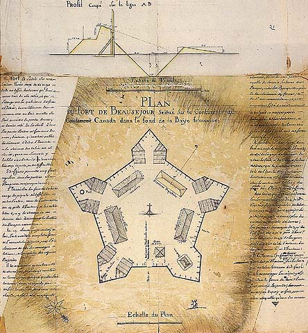
Plan du Fort Beausejour, Isthmus of Chignecto
by Louis Franquet, 1751
Source:
http://www.culture.fr/culture/nllefce/fr/plan6.htm
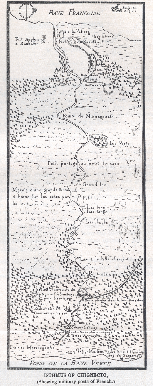
French Map of the route between
Forts Beausejour and Gaspereau
Source:
http://www.blupete.com/Hist/NovaScotiaBk1/Part5/Maps/isthmusTrail.gif
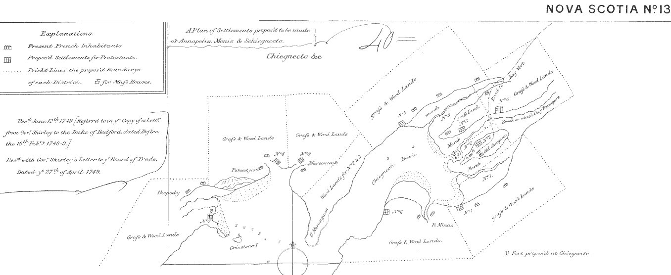
June 12th, 1749
A Plan of Settlements proposed to be made at
Annapolis, Menis and Schicgnecto
(Annapolis, Minas and Chignecto)
Source:
http://www.blupete.com/Hist/NovaScotiaBk1/Part5/Maps/map.gif
1750 November
First Astronomical Observatory
The first astronomical observatory in Canada was established at Louisbourg, Ile Royale (Cape Breton Island) by the Marquis de Chabert.
Source: Department of Canadian Heritage, List of important anniversaries
http://www.pch.gc.ca/ceremonial-symb/english/day_annivers.html
1751
First Printer in Canada
The printing industry was introduced to Canada in 1751 by Bartholomew Green of Halifax, Nova Scotia.
[Source: National Museum of Science and Technology
Collection and Research Division's Transformation Series No. 3
Technology and Canadian Printing: A History from Lead Type to Lasers, by Bryan Dewalt.]
1751 March 1
New Governor for Isle Royale
Jean-Louis, Compte de Raymond, was appointed governor of Isle Royale (Cape Breton Island) on this day. His headquarters were in Louisbourg.
[The National Post, 1 March 2000]
1752
Harbour Ferry Begins Operation
The Halifax-Dartmouth ferry service, established in 1752, relied on a large rowboat and a canvas sail to transport residents between Dartmouth and the larger city across the harbour. The rowboat was later replaced by horses used to power a paddle wheel. In 2000, the ferry — still providing daily passenger service — had become the oldest salt-water ferry in North America.
[The National Post, 23 May 2000]
Monday, 1752 March 23 (Julian calendar)
Monday, 1752 April 3 (Gregorian calendar)
Oldest Newspaper in Canada
Begins Publication
On this day, the oldest newspaper in Canada began publication in Halifax, Nova Scotia, as the Halifax Gazette. In 1766, the name was changed to the Nova Scotia Gazette. In 1999 it continues regular publication once a week as the
Royal Gazette.

Whaddya mean, "on this day"? There are two dates at the top of this item.
Yes, there are two dates, but they both identify the same day, the day on which the first issue of the Halifax Gazette was published. The date printed on the pages of that first issue is "Monday, March 23, 1752." But there's a problem with that; if you check you will find that March 23, 1752 was a Thursday, not a Monday.
The explanation lies in the calendar. According to the Gregorian Calendar (the ordinary everyday calendar we now use), in 1752 March 23rd was a Thursday. But, according to the Julian Calendar, in 1752 March 23rd was a Monday. The Julian Calendar was the ordinary everyday calendar in use in Great Britain — and in all colonies and territories, including Halifax, controlled by Great Britain (except Scotland) — at the time the first issue of The Halifax Gazette was published, and this issue was dated in that calendar.
A few months later, in September 1752, the civil calendar (the calendar used by everyone for ordinary everyday purposes) was changed from Julian to Gregorian in Great Britain and in all colonies and territories then controlled by Great Britain (except Scotland). The first few issues of The Halifax Gazette were published, and dated, according to the Julian Calendar, but after 14 September 1752 the Gregorian Calendar was used.
The correct date, in the Gregorian Calendar, of the first issue of The Halifax Gazette is Monday, April 3rd, 1752. For example, the 250th anniversary of the publication of that first issue will be coming soon, in 2002. If someone wants to celebrate this 250th anniversary, the correct date (using our current calendar) will be April 3rd, 2002.
There are numerous websites with additional information about the Julian and Gregorian Calendars, and how to convert dates in one to the equivalent dates in the other. One useful webpage is http://www.geo.ed.ac.uk/home/scotland/time2.html
Another useful webpage is
Frequently Asked Questions about Calendars
http://www.pip.dknet.dk/~c-t/calendar.html
|

Front page detail, Halifax Gazette, 23 March 1752 OS
On the 13th of May last, an Act passed for regulating the Com-
mencement of the Year, and for correcting the Kalendar now in
Use; to extend throughout all of his Majesty's Dominions. [The Par-
ticulars of which will be published in our next.]
|
Source: Halifax Gazette, 23 March 1752 OS, front page
Reproduced from the National Library of Canada's website
http:www.nlc-bnc.ca/
1752 September
Eleven Days Missing
Nineteen days hath September
The month of September usually contains 30 days, but in 1752 there was a special September with only 19 days. Eleven days, September 2 through 13 inclusive, were omitted from the calendar.
                              SEPTEMBER 1752
                      Great Britain (except Scotland)
                             and all Colonies

                 Mon   Tue   Wed   Thu   Fri   Sat   Sun

                       1     2     14    15    16    17

                 18    19    20    21    22    23    24

                 25    26    27    28    29    30
This change was part of the conversion from the Julian calendar to the Gregorian calendar, and applied throughout Great Britain (except Scotland) and in all territories and colonies then controlled by Great Britain. This included the Thirteen Colonies along the eastern coast of North America which would rebel a generation later. Halifax and those parts of Nova Scotia under the control of London were also included. It most emphatically did not apply in those territories, for example Louisbourg on Cape Breton Island, then under the control of Paris; France had converted to the Gregorian calendar centuries earlier.
1755
Early Roads
By the year 1755, paths in the forests had been made passable for overland transportation between Minas and Annapolis, Minas and Pisiquid (now known as Windsor), and Pisiquid and the new British capital, Halifax.
[The Kentville Advertiser, 9 August 2002]
This information appeared in Ed Coleman's regular column in the
Kentville Advertiser on 9 August 2002. Mr. Coleman was quoting
from a "detailed thesis on pre-Loyalist settlements around Minas
Basin," written in 1953 as a requirement for his M.A. degree by
James Stuart Martell. "Mr. Martell's completed thesis of just over
300 pages was bound in hardcover and distributed in the public
library system." Mr. Coleman was "reading a copy borrowed
from the Kentville branch."
|
1755 February 13
John Mitchell's Map, 1755
The most important map in North American history
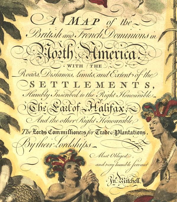
Source: Geography and Map Division of the U.S. Library of Congress
http://memory.loc.gov/ammem/gmdhtml/gmdhome.html
The Mitchell Map — about 2.0 metres 6½ feet wide by 1.4 metres 4½ feet high — has been described, and rightly so, as the most important map in North American history. The first edition of the map was entitled A Map of the British and French Dominions in North America ..., and bore the copyright date of February 13th, 1755. The most comprehensive map of North America produced during the Colonial Era, it represented the various territorial claims made by not only the competing British and French empires but also by the various British colonies. It has been used, as recently as 1932, in legal disputes between eastern states of the United States. More importantly, it was the map on which the boundaries of the new United States were defined by American and British negotiators in Paris in 1782-83; in that capacity, it has continued to be of importance right up to the 1980s US-Canadian dispute over the Gulf of Maine fisheries.
When Richard Oswald used a fourth edition Mitchell Map during the preliminary negotiations at the Treaty of Paris, in late 1782, he annotated his map with a series of quite thick lines representing the different treaties that affected eighteenth-century North America. These lines represented:
red and blue The British interpretation of British boundaries as defined by the Treaty of Utrecht (1713-14). This boundary ran up the Mississippi (the limit of Spanish territory), then up the Illinois River to Lake Michigan, around what is today southern Ontario to the St. Lawrence and thence to the sea.
red and pink The boundary of Nova Scotia...as defined by the Treaty of Utrecht...
John Mitchell's Map
John Mitchell's Map: Introduction and Overview
http://www.usm.maine.edu/~maps/mitchell/intro.html
John Mitchell's Map: The Irony of Empire
http://www.usm.maine.edu/~maps/mitchell/irony.html
The Treaty of Utrecht, Article 13: The Island called Newfoundland...
http://www.heritage.nf.ca/exploration/utrecht.html
http://collections.ic.gc.ca/placentia/troutr.htm
1755 April 14
Colonial Governors Meet at Alexandria
The French and Indian War, 1754-1763
a.k.a. The Seven Years War, 1756-1763
The confrontation at Fort Necessity in the summer of 1754 was an early skirmish in the war fought by England and France for control of the North American continent. It marks the opening episode of a worldwide struggle known in North America as the French and Indian War and elsewhere as the Seven Years' War. It ended in 1763 with the expulsion of French power from North America and India.
Hostilities began in North America two years before they did in Europe, with Washington's surrender at Fort Necessity in July 1754. (The site of Fort Necessity is located in southwestern Pennsylvania about 18 km east of modern Uniontown.)
In April 1755, a meeting of six Royal Governors — Shirley, of Massachusetts; De Lancey, of New York; Sharpe, of Maryland; Morris, of Pennsylvania; Dobbs, of North Carolina; and Dinwiddie, of Virginia — at Carlyle House in Alexandria, Virginia, (six km southwest from the modern Pentagon building in Washington, D.C.) with General Edward Braddock, the newly-arrived commander in chief of the British forces in North America, identified four main objectives for the coming military campaign:
- Fort Duquesne in western Pennsylvania
- Fort Niagara in western New York
- Fort Beausejour in Nova Scotia, and
- Fort St. Frederic at Crown Point on Lake Champlain, in northern New York
Three separate expeditions were planned for 1755. One was to proceed against Fort Duquesne, led by General Braddock. A second was to attack Fort Niagara at the mouth of the Niagara River, and Fort Frontenac at the foot of Lake Ontario on the site of Kingston, and was to be led by General Shirley. A third expedition, led by Colonel William Johnson (then the government superintendent of Indian affairs among the Six Nations), was to attempt the seizure of Crown Point on Lake Champlain – in 1755 Fort St. Frederic was the third strongest work in North America held by the French, after Quebec and Louisbourg. A fourth expedition had already been planned in the east, for the expulsion of the French from Nova Scotia, and possibly the recapture of Louisburg.
1755 June 16
Fort Beausejour Captured
The first land battle between England and France
for control of North America
In September 1750, Major Charles Lawrence arrived with 800 British troops at Beaubassin (now known as Fort Lawrence) on the edge of British-controlled territory, to establish a fort to take possession of the Isthmus of Chignecto, near the present-day border between Nova Scotia and New Brunswick.
The new fort was named Fort Lawrence. The outer walls, measuring about 100 metres square, were erected in two days while the workers were under fire from Micmac Indians loyal to the French.
At this time, Ile Royale (Cape Breton Island) and Ile Ste. Jean (Prince Edward Island) were still held by the French military forces. The commanders of these forces, backed by the government of France, had every intention of holding these territories. Fort Lawrence was built to establish a defensive position on the boundary of the new British colony.
The next year, in 1751, the French built Fort Beausejour. On 4 June 1755, Lieut.-Col. Robert Moncton led 2,250 troops from Fort Lawrence on an attack of Fort Beausejour. This was the first land battle between England and France for control of North America.
Fort Beausejour was captured on 16 June 1755 and was renamed Fort Cumberland.
In 1755, Lieut.-Colonel John Winslow commanded the first batallion of Shirley's regiment at the siege and capture of Fort Beausejour. John Winslow was born in 1702, son of Hon. Isaac Winslow of Marshfield, Massachusetts, and great-grandson of Edward Winslow, first Governor of Plymouth Colony. John Winslow's portrait is now in Pilgrim Hall, Plymouth. In 1773, Joshua Winslow, nephew of John Winslow, was one of the consignees of the cargo of tea thrown overboard into Boston Harbour by a mob.
The Antigonish Casket, 15 September 1999
The Amherst Citizen, 25 September 1999
1755 June 21
Fort Gaspereau Captured
On this day Fort Gaspereau was captured by the British; it was demolished the following year. The site of Fort Gaspereau is in modern Port Elgin, New Brunswick.
1755 November 18 11:35 UTC (GMT)
The Cape Ann Earthquake
Cape Ann, Massachusetts
This earthquake was reported from Halifax, Nova Scotia, south to the Chesapeake Bay in Maryland, and from Lake George, New York, east to a ship 300 kilometres east of Cape Ann. The location of the ship is thought to be near the epicenter, because the shock was felt so strongly that those on board believed the ship had run aground.
Several aftershocks occurred. This earthquake caused the heaviest damage in the region around Cape Ann and Boston. Stone fences were thrown down throughout the countryside, particularly on a line extending from Boston to Montreal. New springs formed, and old springs dried up. At Scituate (on the coast southeast of Boston), Pembroke (about 15 kilometres southwest of Scituate), and Lancaster (about 40 kilometres west of Boston), cracks opened in the earth. Water and fine sand issued from some of the ground cracks at Pembroke.
Source: Largest Earthquake in Massachusetts
http://wwwneic.cr.usgs.gov/neis/eqlists/USA/1755_11_18.html
1755 December 10
First Post Office in Canada
Benjamin Franklin, Postmaster
The first official Post Office, in what is now Canada, was opened in Halifax in 1755. Benjamin Franklin, printer in Philadelphia, and William Hunter, the Deputy Postmasters General for the British Colonies in North America, were in charge.
Source: Canada Post
http://www.canadapost.ca/corporate/about/jobs/traditions-e.asp
On 31 January 1774, Benjamin Franklin was dismissed as Deputy Postmaster General because of his writings and other activities associated with the American Revolution. Hugh Finlay, along with John Foxcroft, was then appointed joint Deputy Postmaster General for the northern district of Britain's North American colonies, extending from Quebec to Virginia.
Source: Chronology of Canadian Postal History
http://www.civilization.ca/cpm/chrono/chs1760e.html
1756 May-June
The North American War Expands to Europe
England declared war on France, 17 May 1756
France declared war on England, 9 June 1756
The Seven Years War, 1756-1763
a.k.a. The French and Indian War, 1754-1763
England declared war on France on account of the attack upon Minorca on May 17th, 1756. On June 9th, 1756, France declared war on England.
[Von Ruville's biography of Pitt (London: Heinemann, 1907) vol. 1, p. 391.]
Source:
Peter Landry's history of Nova Scotia
http://www.blupete.com/Hist/NovaScotiaBk1/Part6/Ch02fn.htm
1758 February 7
First Elected Assembly Planned
On this day, Charles Lawrence, the governor of Nova Scotia, proclaimed a resolution passed by the provincial council to organize the first legislative assembly in what is now Canada.
[The National Post, 7 February 2000]
1758 July 26
Louisbourg Surrenders
Louisbourg, the great French citadel on Cape Breton Island — at the time the strongest fortress in North America — surrendered after an eight-week seige to a British force of 27,000 men and 157 ships. With the surrender, the French were driven from the Maritime Provinces.
[The National Post, 26 July 2001]
The great fortress of Louisbourg was built (1720-40) by France as its Gibraltar in America. Plans were drawn by the great French engineer Vauban, but the work was poorly done, and the garrison was inadequately supplied and at odds with the civilian population. French privateers, using the harbor as a base, preyed on New England fishermen working the Grand Banks, until 1745, when a small force of New Englanders under William Pepperrell, supported by a fleet of merchant men commanded by Sir Peter Warren, attacked Louisbourg and forced its surrender. Three years later it was returned to France by the Treaty of Aix-la-Chapelle, in exchange for Madras, India, but in 1758 it fell to a British land and sea attack led by Gen. Jeffrey Amherst and Admiral Boscawen, which reduced it to ruins.
Source:
The Society of Colonial Wars in Connecticut
http://www.colonialwarsct.org/1745.htm
Reference:
Louisbourg Ben Franklin warned that it would be a "hard nut to crack" — but in 1745 a ragtag army of New Englanders captured France's most imposing North American stronghold...
http://www.thehistorynet.com/AmericanHistory/articles/0895_text.htm
1758 October 2
First Elected Assembly Convened
On this day, an elected Assembly was convened at Halifax, the first in what is now Canada.
[The Government of Nova Scotia, by J.M. Beck, University of Toronto Press, 1957]
The first legislative assembly was elected in Nova Scotia in 1758. Prince Edward Island followed suit in 1773, New Brunswick in 1785, then Lower Canada (Quebec) and Upper Canada (Ontario) in 1792. Still, the power of government remained in the hands of executive council members nominated by colonial governors, who were themselves nominated by the British Crown. Council members could block any law adopted by an assembly and were in no way accountable to the electorate. Nova Scotia again innovated in 1848, when it inaugurated the first elected responsible government in a British colony. Six years later, all colonies had responsible government. From then on, governments would have to answer to the electors.
Source: Elections Canada website
http://www.civilization.ca/membrs/canhist/elections/el_013_e.html
Nova Scotia (which, till 1784, included what is now New Brunswick) was the first part of Canada to secure representative government. In 1758, it was given an assembly, elected by the people. Prince Edward Island followed in 1773; New Brunswick at its creation in 1784; Upper and Lower Canada (the predecessors of the present Ontario and Quebec) in 1791; and Newfoundland in 1832. In January 1848, Nova Scotia was also the first part of Canada to win responsible government: government by a Cabinet answerable to, and removable by, a majority of the assembly. New Brunswick followed a month later, in February 1848; the Province of Canada (a merger of Upper and Lower Canada formed in 1840) in March; Prince Edward Island in 1851; and Newfoundland in 1855.
Source: How Canadians Govern Themselves by Eugene Forsey
http://www.parl.gc.ca/36/refmat/library/forsey/parlgov-e.htm

First page of Nova Scotia Statutes of 1758
Source:
The Legislative Assembly of Nova Scotia 1758-1983: A Biographical Directory, edited and revised by Shirley B. Elliott, 1984, ISBN 088871050X; This volume was prepared as a contribution of the Public Archives of Nova Scotia to the celebration of the bicentenary of the establishment of representative government in Canada.
Province House, in downtown Halifax, is Canada's oldest legislature building, yet the Nova Scotia legislature had been in existence for sixty-one years before it could claim a building of its own. Its first meeting on October 2, 1758 took place at the court house situated at the corner of Argyle and Buckingham streets; later the assembly moved to rented quarters in various locations in the town. As early as 1787 there was talk of a proper seat of government and a suitable site was purchased in the south suburbs. This location, however, did not meet with unanimous approval...
Source: The Restoration of Province House
http://www.parl.gc.ca/infoparl/English/11n1_88_e.htm
1758 October
The Halifax Rating
Different colonies rated coins differently. Sometimes, certain coins were deliberately overrated (i.e., overvalued) or underrated (undervalued) relative to others, given their weight in gold or silver, in order to encourage or discourage their use. In such circumstances, overrated coins drove underrated coins from circulation — an application of Gresham's Law, "bad money drives out good." Underrated coins were typically hoarded or shipped to colonies that valued them more highly. To counteract this, colonial legislatures periodically revised their ratings. Ratings were also revised in response to other factors, including the decline in the value of silver relative to gold throughout the eighteenth and nineteenth centuries and the gradual wearing of old coins (which lowered their weight and reduced their intrinsic value).
One rating that became particularly important in British North America was the Halifax rating. Named after the city of Halifax, where it was first used, this rating was given legal standing by an act of the first Nova Scotia House of Assembly in 1758. This rating used pounds, shillings, and pence (£, s. and d.) as the unit of account and valued one Spanish (or colonial Spanish) silver dollar weighing 420 grains (385 grains of pure silver) at five shillings, local currency. This valuation of the Spanish dollar, the most common coin in circulation at that time, was to be used in settling debts. In effect, the Spanish dollar became legal tender in Nova Scotia.
Although the British imperial authorities overturned the legislation in 1762, since it did not conform to the 1707 Imperial Act, the rating remained in common use and was later adopted in Quebec by the British authorities after the Seven Years' War, as well as in New Brunswick and Prince Edward Island. The Halifax rating, with some modifications, persisted well into the mid-1800s.
In contrast, following the U.S. War of Independence, Upper Canada used the York rating, as did merchants in Montreal, for a time. This rating had originally been established in New York and was brought to Upper Canada by Loyalist immigrants. In York currency, one Spanish dollar was valued at eight shillings. Although an 1821 act re-established the use of the Halifax rating in Upper Canada and, hence, valued one Spanish dollar at five shillings, the York rating remained in use in rural areas until the unification of Upper and Lower Canada in 1841.
Source:
A History of the Canadian Dollar
http://www.bank-banque-canada.ca/english/dollar_book/full_text-e.htm
At that time, gold and silver were weighed by the Troy Weight system
(different from the Avoirdupois Weight system) in which the "grain"
was an important unit of weight, often used for small items such as coins
and jewellery. The grain, as a unit of measure, is now obsolete and is
unfamiliar to most people.
To convert grains into modern measures of weight, we use:
1 grain = 64.81 milligrams
according to the International Standard, 1913.
[From Handbook of Engineering Fundamentals first edition,
edited by Ovid W. Esbach, John Wiley & Sons, New York, 1936]
Thus 420 grains = 27.2 grams
The "Spanish silver dollar weighing 420 grains" (mentioned above)
weighed about 27 grams. For comparison, the modern plated
steel-core 25¢ coin (quarter) introduced as standard Canadian
currency in 2000, weighs 4.40g. The Spanish silver dollar coin weighed
a bit more than six modern Canadian quarters.
|
1759
Sambro Lighthouse Completed
In 1752 — only three years after Halifax was founded — the Governor tried to raise money through a lottery to build a lighthouse to warn vessels away from what were known as the Sambro Ledges or Shoals at the mouth of Halifax harbour. But the lottery flopped and the ticket money had to be refunded. In 1758, the Nova Scotia General Assembly passed an act to authorize the building of a lighthouse financed by "duties paid on spiritous liquors," and in 1759 the 13-metre 44-foot structure, built with granite stones in the British style , was completed. As Captain James Cook noted in 1762, the Sambro light watched Admiral James Wolfe lead the British fleet out of Halifax harbour, to the battle of Quebec in 1759. In 1895, adventurer Joshua Slocum set out to become the first person to sail alone around the world with a final glance back at the Sambro light. He wrote: "I watched light after light sink astern as I sailed into the unbounded sea, 'til Sambro was below the horizon." In 1998, 239 years later, Sambro was the oldest working lighthouse in North America.
[Excerpted from pages A1 & A2, The Globe and Mail, 2 October 1998]
1760 February 9
Destruction of Louisbourg Fortress Begins
On this day, Captain John Byron starts tearing down the fortifications of Louisbourg, Nova Scotia, on orders from William Pitt, the British prime minister.
[The National Post, 9 February 2000]
1760 October 25
Death of King George II,
George III Begins Reign
On this day, George II, King of Great Britain and Ireland, died. He was succeeded on the throne by his grandson George III.
1760 November 3
Slave Auction Advertisement
"Public Auction: On Monday, 3rd of November 1760 — To Be Sold at the house of John Rider, two slaves, viz: boy and girl about eleven years of age; likewise a puncheon of choice old cherry brandy with sundry other articles."

[(newspaper) Halifax Gazette, 1 November 1760]
[The Halifax Sunday Daily News, 19 August 2001]
Other Slave Advertisements from Halifax Newspapers
"Just imported, and to be sold by Joshua Mauger, at Major Lockman's store in Halifax, several negro slaves, as follows: A woman aged thirty-five, two boys aged twelve and thirteen repectively, two of eighteen and a man aged thirty"
[Halifax Gazette, 15 May 1752]
"A likely well-made Negro boy, about sixteen years old, is offered for sale..."
[Nova Scotia Gazette and Weekly Chronicle, 28 March 1775]
Source:
(book) Down East, Another Cargo of Tales Told under the Old Town Clock by William Coates Borrett, Imperial Publishing Company Ltd., Halifax, 1945
as quoted in a Letter to the Editor in
The Halifax Sunday Daily News, 26 August 2001
1763 February 10
Treaty of Paris Ends Seven Years War
On this day, France signed the Treaty of Paris, ending the Seven Years War and giving up Canada, keeping only the islands of St. Pierre and Miquelon. Under the Treaty, France also kept part of Louisiana.
[The National Post, 10 February 2000]
The Treaty of Paris
10 February 1763
The definitive Treaty of Peace and Friendship between his Britannick Majesty, the Most Christian King, and the King of Spain. Concluded at Paris the 10th day of February, 1763. To which the King of Portugal acceded on the same day...
Article IV
His Most Christian Majesty renounces all pretensions which he has heretofore formed or might have formed to Nova Scotia or Acadia in all its parts, and guaranties the whole of it, and with all its dependencies, to the King of Great Britain: Moreover, his Most Christian Majesty cedes and guaranties to his said Britannick Majesty, in full right, Canada, with all its dependencies, as well as the island of Cape Breton, and all the other islands and coasts in the gulph and river of St. Lawrence, and in general, every thing that depends on the said countries, lands, islands, and coasts, with the sovereignty, property, possession, and all rights acquired by treaty, or otherwise, which the Most Christian King and the Crown of France have had till now over the said countries, lands, islands, places, coasts, and their inhabitants, so that the Most Christian King cedes and makes over the whole to the said King, and to the Crown of Great Britain, and that in the most ample manner and form, without restriction, and without any liberty to depart from the said cession and guaranty under any pretence, or to disturb Great Britain in the possessions above mentioned. His Britannick Majesty, on his side, agrees to grant the liberty of the Catholick religion to the inhabitants of Canada: he will, in consequence, give the most precise and most effectual orders, that his new Roman Catholic subjects may profess the worship of their religion according to the rites of the Romish church, as far as the laws of Great Britain permit. His Britannick Majesty farther agrees, that the French inhabitants, or others who had been subjects of the Most Christian King in Canada, may retire with all safety and freedom wherever they shall think proper, and may sell their estates, provided it be to the subjects of his Britannick Majesty, and bring away their effects as well as their persons, without being restrained in their emigration, under any pretence whatsoever, except that of debts or of criminal prosecutions: The term limited for this emigration shall be fixed to the space of eighteen months, to be computed from the day of the exchange of the ratification of the present treaty...
Note:
The name "Nova Scotia" is highlighted above.
This emphasis does not appear in the original.
|
Reference:
The complete text of the Treaty of Paris, 1763, is available at
http://www.solon.org/Constitutions/Canada/English/
PreConfederation/Treaty_of_Paris_1763.html
Note: At this website, the complete Treaty text is reproduced in the original French. If you scroll halfway down the webpage, you will find the complete English translation.
1763 October 7
Cape Breton and P.E.I.
Annexed to Nova Scotia
A proclamation dated 7 October 1763 and signed by King George III, annexed St. John's and Cape Breton Islands to Nova Scotia. In the case of the former, now known as Prince Edward Island, the action had little significance, for within six years the authorities in England had reconsitiuted it as a distinct province.
Sources:
The Government of Nova Scotia, by J.M. Beck, University of Toronto Press, 1957,
The Halifax Daily News, 7 October 1999, and
The National Post, 7 October 1999.
We have also, with the advice of our Privy Council, thought fit to annex the Islands of St. John's and Cape Breton, or Isle Royale, with the lesser Islands adjacent thereto, to our Government of Nova Scotia.
The Royal Proclamation of October 7, 1763
By the King — A Proclamation
George R.
Purpose
Whereas We have taken into Our Royal Consideration the extensive and valuable Acquisitions in America, secured to our Crown by the late Definitive Treaty of Peace, concluded at Paris the 10th Day of February last; and being desirous that all Our loving Subjects, as well of our Kingdom as of our Colonies in America, may avail themselves with all convenient Speed, of the great Benefits and Advantages which must accrue therefrom to their Commerce, Manufactures, and Navigation, We have thought fit, with the Advice of our Privy Council, to issue this our Royal Proclamation, hereby to publish and declare to all our loving Subjects, that we have, with the Advice of our Said Privy Council, granted our Letters Patent, under our Great Seal of Great Britain, to erect, within the Countries and Islands ceded and confirmed to Us by the said Treaty, Four distinct and separate Governments, styled and called by the names of Quebec, East Florida, West Florida and Grenada, and limited and bounded as follows, viz.
First — The Government of Quebec bounded on the Labrador Coast by the River St. John, and from thence by a Line drawn from the Head of that River through the Lake St. John, to the South end of the Lake Nipissing; from whence the said Line, crossing the River St. Lawrence, and the Lake Champlain, in 45 Degrees of North Latitude, passes along the High Lands which divide the Rivers that empty themselves into the said River St. Lawrence from those which fall into the Sea; and also along the North Coast of the Baye des Chaleurs, and the Coast of the Gulph of St. Lawrence to Cape Rosieres, and from thence crossing the Mouth of the River St. Lawrence by the West End of the Island of Anticosti, terminates at the aforesaid River of St. John.
Secondly — The Government of East Florida, bounded to the Westward by the Gulph of Mexico and the Apalachicola River; to the Northward by a Line drawn from that part of the said River where the Chatahouchee and Flint Rivers meet, to the source of St. Mary's River. and by the course of the said River to the Atlantic Ocean; and to the Eastward and Southward by the Atlantic Ocean and the Gulph of Florida, including all Islands within Six Leagues of the Sea Coast.
Thirdly — The Government of West Florida, bounded to the Southward by the Gulph of Mexico, including all Islands within Six Leagues of the Coast; from the River Apalachicola to Lake Pontchartrain; to the Westward by the said Lake, the Lake Maurepas, and the River Mississippi; to the Northward by a Line drawn due East from that part of the River Mississippi which lies in 31 Degrees North Latitude. to the River Apalachicola or Chatahouchee; and to the Eastward by the said River.
Fourthly — The Government of Grenada, comprehending the Island of that name, together with the Grenadines, and the Islands of Dominico, St. Vincent's and Tobago.
And to the end that the open and free Fishery of our Subjects may be extended to and carried on upon the Coast of Labrador, and the adjacent Islands, We have thought fit, with the advice of our said Privy Council to put all that Coast, from the River St. John's to Hudson's Streights, together with the Islands of Anticosti and Madelaine, and all other smaller Islands lying upon the said Coast, under the care and Inspection of our Governor of Newfoundland.
We have also, with the advice of our Privy Council. thought fit to annex the Islands of St. John's
[now Prince Edward Island]
and Cape Breton, or Isle Royale, with the lesser Islands adjacent thereto, to our Government of Nova Scotia.
We have also, with the advice of our Privy Council aforesaid, annexed to our Province of Georgia all the Lands lying between the Rivers Alatamaha and St. Mary's.
New Governments to have General Assemblies and Make Laws
And whereas it will greatly contribute to the speedy settling of our said new Governments, that our loving Subjects should be informed of our Paternal care, for the security of the Liberties and Properties of those who are and shall become Inhabitants thereof, We have thought fit to publish and declare, by this Our Proclamation, that We have, in the Letters Patent under our Great Seal of Great Britain, by which the said Governments are constituted, given express Power and Direction to our Governors of our Said Colonies respectively, that so soon as the state and circumstances of the said Colonies will admit thereof, they shall, with the Advice and Consent of the Members of our Council, summon and call General Assemblies within the said Governments respectively, in such Manner and Form as is used and directed in those Colonies and Provinces in America which are under our immediate Government: And We have also given Power to the said Governors, with the consent of our Said Councils, and the Representatives of the People so to be summoned as aforesaid, to make, constitute, and ordain Laws, Statutes, and Ordinances for the Public Peace, Welfare, and good Government of our said Colonies, and of the People and Inhabitants thereof, as near as may be agreeable to the Laws of England, and under such Regulations and Restrictions as are used in other Colonies; and in the mean Time, and until such Assemblies can be called as aforesaid, all Persons Inhabiting in or resorting to our Said Colonies may confide in our Royal Protection for the Enjoyment of the Benefit of the Laws of our Realm of England; for which Purpose We have given Power under our Great Seal to the Governors of our said Colonies respectively to erect and constitute, with the Advice of our said Councils respectively, Courts of Judicature and public Justice within our Said Colonies for hearing and determining all Causes, as well Criminal as Civil, according to Law and Equity, and as near as may be agreeable to the Laws of England, with Liberty to all Persons who may think themselves aggrieved by the Sentences of such Courts, in all Civil Cases, to appeal, under the usual Limitations and Restrictions, to Us in our Privy Council.
Grants for Settlement
We have also thought fit, with the advice of our Privy Council as aforesaid, to give unto the Governors and Councils of our said Three new Colonies upon the Continent, full Power and Authority to settle and agree with the Inhabitants of our said new Colonies or with any other Persons who shall resort thereto, for such Lands, Tenements and Hereditaments, as are now or hereafter shall be in our Power to dispose of; and them to grant to any such Person or Persons upon such Terms, and under such moderate Quit-Rents, Services and Acknowledgments, as have been appointed and settled in our other Colonies, and under such other Conditions as shall appear to us to be necessary and expedient for the Advantage of the Grantees, and the Improvement and settlement of our said Colonies.
Soldier Settlement
And Whereas, We are desirous, upon all occasions, to testify our Royal Sense and Approbation of the Conduct and bravery of the Officers and Soldiers of our Armies, and to reward the same, We do hereby command and impower our Governors of our said Three new Colonies, and all other our Governors of our several Provinces on the Continent of North America, to grant without Fee or Reward, to such reduced Officers as have served in North America during the late War, and to such Private Soldiers as have been or shall be disbanded in America, and are actually residing there, and shall personally apply for the same, the following Quantities of Lands, subject, at the Expiration of Ten Years, to the same Quit-Rents as other Lands are subject to in the Province within which they are granted, as also subject to the same Conditions of Cultivation and Improvement; viz.
To every Person having the Rank of a Field Officer — 5,000 Acres.
To every Captain — 3,000 Acres.
To every Subaltern or Staff Officer — 2,000 Acres.
To every Non-Commission Officer — 200 Acres.
To every Private Man — 50 Acres.
5000 acres = 2023 hectares
3000 acres = 1214 hectares
2000 acres = 809 hectares
200 acres = 81 hectares
50 acres = 20 hectares
|
We do likewise authorize and require the Governors and Commanders in Chief of all our said Colonies upon the Continent of North America to grant the like Quantities of Land, and upon the same conditions, to such reduced Officers of our Navy of like Rank as served on board our Ships of War in North America at the times of the Reduction of Louisbourg and Quebec in the late War, and who shall personally apply to our respective Governors for such Grants.
The Indian Provisons
And whereas it is just and reasonable, and essential to our Interest, and the Security of our Colonies, that the several Nations or Tribes of Indians with whom We are connected, and who live under our Protection, should not be molested or disturbed in the Possession of such Parts of Our Dominions and Territories as, not having been ceded to or purchased by Us, are reserved to them, or any of them, as their Hunting Grounds — We do therefore, with the Advice of our Privy Council, declare it to be our Royal Will and Pleasure, that no Governor or Commander in Chief in any of our Colonies of Quebec, East Florida. or West Florida, do presume, upon any Pretence whatever, to grant Warrants of Survey, or pass any Patents for Lands beyond the Bounds of their respective Governments. as described in their Commissions: as also that no Governor or Commander in Chief in any of our other Colonies or Plantations in America do presume for the present, and until our further Pleasure be known, to grant Warrants of Survey, or pass Patents for any Lands beyond the Heads or Sources of any of the Rivers which fall into the Atlantic Ocean from the West and North West, or upon any Lands whatever, which, not having been ceded to or purchased by Us as aforesaid, are reserved to the said Indians, or any of them.
And We do further declare it to be Our Royal Will and Pleasure, for the present as aforesaid, to reserve under our Sovereignty, Protection, and Dominion, for the use of the said Indians, all the Lands and Territories not included within the Limits of Our said Three new Governments, or within the Limits of the Territory granted to the Hudson's Bay Company, as also all the Lands and Territories lying to the Westward of the Sources of the Rivers which fall into the Sea from the West and North West as aforesaid.
And We do hereby strictly forbid, on Pain of our Displeasure, all our loving Subjects from making any Purchases or Settlements whatever, or taking Possession of any of the Lands above reserved, without our especial leave and Licence for that Purpose first obtained.
And We do further strictly enjoin and require all Persons whatever who have either wilfully or inadvertently seated themselves upon any Lands within the Countries above described. or upon any other Lands which, not having been ceded to or purchased by Us, are still reserved to the said Indians as aforesaid, forthwith to remove themselves from such Settlements.
And whereas great Frauds and Abuses have been committed in purchasing Lands of the Indians, to the great Prejudice of our Interests. and to the great Dissatisfaction of the said Indians: In order, therefore, to prevent such Irregularities for the future, and to the end that the Indians may be convinced of our Justice and determined Resolution to remove all reasonable Cause of Discontent, We do, with the Advice of our Privy Council strictly enjoin and require, that no private Person do presume to make any purchase from the said Indians of any Lands reserved to the said Indians, within those parts of our Colonies where We have thought proper to allow Settlement: but that, if at any Time any of the Said Indians should be inclined to dispose of the said Lands, the same shall be Purchased only for Us, in our Name, at some public Meeting or Assembly of the said Indians, to be held for that Purpose by the Governor or Commander in Chief of our Colony respectively within which they shall lie: and in case they shall lie within the limits of any Proprietary Government, they shall be purchased only for the Use and in the name of such Proprietaries, conformable to such Directions and Instructions as We or they shall think proper to give for that Purpose: And we do, by the Advice of our Privy Council, declare and enjoin, that the Trade with the said Indians shall be free and open to all our Subjects whatever, provided that every Person who may incline to Trade with the said Indians do take out a Licence for carrying on such Trade from the Governor or Commander in Chief of any of our Colonies respectively where such Person shall reside, and also give Security to observe such Regulations as We shall at any Time think fit, by ourselves or by our Commissaries to be appointed for this Purpose, to direct and appoint for the Benefit of the said Trade:
And we do hereby authorize, enjoin, and require the Governors and Commanders in Chief of all our Colonies respectively, as well those under Our immediate Government as those under the Government and Direction of Proprietaries, to grant such Licences without Fee or Reward, taking especial Care to insert therein a Condition, that such Licence shall be void, and the Security forfeited in case the Person to whom the same is granted shall refuse or neglect to observe such Regulations as We shall think proper to prescribe as aforesaid.
And we do further expressly conjoin and require all Officers whatever, as well Military as those Employed in the Management and Direction of Indian Affairs, within the Territories reserved as aforesaid for the use of the said Indians, to seize and apprehend all Persons whatever, who standing charged with Treason, Misprisions of Treason, Murders, or other Felonies or Misdemeanors, shall fly from Justice and take Refuge in the said Territory, and to send them under a proper guard to the Colony where the Crime was committed, of which they stand accused, in order to take their Trial for the same.
Given at our Court at St. James's the 7th Day of October 1763, in the Third Year of our Reign.
(signed by George III)
George the Third, by the grace of God, King of Great Britain, France and Ireland, Defender of the Faith, Duke of Brunswick and Lunenbourg, Arch-Treasurer, and Prince Elector of the Holy Roman Empire, &c.
Note:
The name "Nova Scotia" is highlighted above.
This emphasis does not appear in the original.
|
References:
Each of these websites contains the complete text of the Proclamation:
http://www.bloorstreet.com/200block/rp1763.htm
http://www.solon.org/Constitutions/Canada/English/PreConfederation/rp_1763.html
http://iquebec.ifrance.com/pol/english/national/docA-01.html
http://dspace.dial.pipex.com/town/terrace/adw03/c-eight/1763proc.htm
http://www.sit-rep.com/h10a.htm
http://www.yale.edu/lawweb/avalon/proc1763.htm
http://www.geocities.com/CapitolHill/Lobby/9196/prod04.htm
http://www.ushistory.org/declaration/related/proc63.htm
1766
Isaiah Thomas Goes to Halifax
Isaiah Thomas was the leading American printer and publisher of his day. He was born on January 19, 1749, to an old but quite poor Boston family. His father, Moses, abandoned the family and in 1756 Isaiah was bound out by the Overseers of the Poor of Boston to a shiftless printer named Zechariah Fowle.
Thomas stayed with him for ten years before running away, first to Halifax, Nova Scotia, and then to Charleston, South Carolina. His vagabond days were exciting and he found himself frequently in difficulty with his employers and the civil authorities. He returned to Boston in 1770 with the first of his three wives and in July went into partnership with his old master, Fowle.
In Boston he continued to harass the authorities and on the night of April 16, 1775, he fled to Worcester, Massachusetts, with press and types. The next year he leased his newspaper, The Massachusetts Spy, and went to Salem in an effort to improve his shaky fortunes. He returned to Worcester in 1778 no richer and without his wife, who had run off with Benjamin Thompson the Tory, later Count Rumford.
In the succeeding years Thomas's fortunes did improve. At the height of his prosperity he employed 150 people in a printing office containing seven presses. In addition, he owned a paper mill, a bindery, and eight branch offices scattered about in Massachusetts, New Hampshire, Vermont, New York, and Maryland. His other business interests included real estate in Boston and other places, as well as shares in a number of Worcester enterprises. When he retired from active business in 1802 he was a wealthy man.
Thereafter he devoted himself to his book The History of Printing in America, With a Biography of Printers & an Account of Newspapers and the American Antiquarian Society, which he founded in 1812. The History of Printing in America first appeared in 1810 and was based on Thomas's long fascination with his trade as well as upon his very extensive library of books and newspapers which he had collected to prepare such a history.
His book is still the beginning point for most investigations into the history of American printing, for he provides the tantalizing clues from which his successors have built their own studies. Further, his personal knowledge of many of the people and events which he describes in a frank and unadorned manner makes excellent and often amusing reading. The History of Printing in America retains the essential beginnings which lead the reader into fascinating byways of American history and the craft which in such large measure perpetuated it. Thomas died on April 4, 1831.
Source:
http://cgi.ebay.com/aw-cgi/eBayISAPI.dll?ViewItem&item=225962340
1766 January 26
The Articles of Agreement
In 1766, Charles Jones and four other men brought
their families from Pennsylvania to the area of
The Bend on the Petitcodiac River in Nova Scotia
(now known as Moncton, New Brunswick)
On January 27, 1766, Charles Jones and eight other interested settlers found themselves sitting in the office of John Hughes, General Merchant, Iron Master and Land Agent. The men were there in response to an advertisement, run by "Franklin and Company" land agents, offering to "any good Protestant family" lands in the British province of Nova Scotia. Associates in the Company were John Hughes, John Cox Jr., and Anthony Wayne. Wayne was introduced to the gentlemen by John Hughes as "my agent in Nova Scotia." Wayne had been successful in acquiring a grant of one township on the Saint John River and one township on the Petitcodiac River. [In 1766, this was part of Nova Scotia.]
The document Jones was about to sign was known as "The Articles of Agreement". In this agreement, the settlers would buy the land from Hughes, but before the deed to the land would be bestowed, they had some work to do. The settlers would first be required to build a house with a brick or stone chimney. The lot was to be fenced, and two acres of Corn Land, one acre of meadow and fifty apple trees were to be planted. It was also understood, by the settlers, that John Hughes would furnish them with supplies to get started.
A total of nine men made their decision that day, but later, four of these men changed their minds. The remaining five — Matthias Somers, Charles Jones, Henrich Stief(Steeves), Michael Lutz and Jacob Trites would leave for their new home on the Petitcodiac River, in April, 1766, as soon as weather permitted.
Source:
Nancy (Jones) Matthews' website
http://personal.nbnet.nb.ca/pebbles2/genpg2.htm
Complete text of The Articles of Agreement
http://personal.nbnet.nb.ca/pebbles2/genpg2a.htm
Articles of Agreement made, Indented, concluded and agreed upon by and between John Hughes of the City of Philadelphia, Merchant of the One part and Matthias Summer, Valentine Miller, Charles Jones, Henry Stief, Andrew Criner, Michael Lutz, Jacob Cline, Matthias Lentz, Jacob Trites. Of the other part Witnesseth that Whereas the said John Hughes hath purchased a Share in two Townships in the Colony of Nova Scotia. One of them situate on the River Petitcodiac and the other on the River St. John's ... In Testimony whereof the said parties have to these presents Interchangeably set their Hands and Seals the Twenty Seventh Day of January in the Year of Our Lord One Thousand Seven Hundred and sixty six ... The said John Hughes further Agrees that the people that he sends to Nova Scotia shall have the use of what Clear Land falls to his share for the space of five Years...
1769 August 4
P.E.I. Separated from N.S.
On this day, the British Crown separated the Island of St. Jean, now known as Prince Edward Island, from Nova Scotia. Of course, the separation was not geographic — Northumberland Strait has been between Nova Scotia and P.E.I. for millennia — but legal and political; for the Island, the administrative functions of government no longer centered in Halifax. After this separation, Nova Scotia still officially included the territory now known as New Brunswick and a large chunk of what is now the state of Maine.
Sources:
The Government of Nova Scotia, by J.M. Beck, University of Toronto Press, 1957
The National Post, 4 August 1999
Wayback Machine
Wayback Machine
http://web.archive.org/index.html
"Use the Wayback Machine to view web sites from the past."
Archive of This Document:
History of Nova Scotia, Chapter 2
The Wayback Machine has copies of this webpage from the early days:
Archived: 2000 August 15
http://web.archive.org/web/20000815195204/http://www.alts.net/ns1625/nshist02.html
Archived: 2000 August 17
http://web.archive.org/web/20000817013421/http://alts.net/ns1625/nshist02.html
Archived: 2000 December 14
http://web.archive.org/web/20001214215600/http://www.littletechshoppe.com/ns1625/nshist02.html
Archived: 2001 January 10
http://web.archive.org/web/20010110013600/http://www.alts.net/ns1625/nshist02.html
Archived: 2001 February 8
http://web.archive.org/web/20010208123855/http://www.alts.net/ns1625/nshist02.html
Archived: 2001 August 16
http://web.archive.org/web/20010816203310/http://alts.net/ns1625/nshist02.html
|
Go To: Index with links to the other chapters
Go To: History of Railway Companies in Nova Scotia
http://alts.net/ns1625/railways.html
Go To: History of Automobiles in Nova Scotia
http://alts.net/ns1625/automobiles.html
Go To: History of Telegraph and Telephone Companies in Nova Scotia
http://alts.net/ns1625/telephone.html
Go To: History of Electric Power Companies in Nova Scotia
http://alts.net/ns1625/electric.html
Go To: Index to other online Nova Scotia History
http://alts.net/ns1625/histindx.html
Go To: Nova Scotia Quotations
http://alts.net/ns1625/quotes.html
Go To: Photographs of War Memorials and Historic Monuments in Nova Scotia
http://www.newscotland1398.net/remem/plaques.html
Go To: Home Page
http://alts.net/ns1625/index.html

W3C HTML Validation Service
http://validator.w3.org/

W3C CSS Validation Service
http://jigsaw.w3.org/css-validator/
Latest content revision: 2003 January 17