| EAST FORK DAIRY CREEK
|
| STREAM MILE INDEX
|
| 2114003000480080
|
| |
| Mile |
Description |
| |
|
| 0.00 |
Confluence with West Fork Dairy Creek - (02114003000480090) |
| |
Start of Dairy Creek RM 10.56 - (02114003000480) |
| 1.24 |
Roy Road Bridge (CR A-159) |
| |
Rated Staff Gage for Stream Flow |
| 2.34 |
Port of Tillamook Bay RR Bridge |
| 3.04 |
Bledsoe Creek (RB-02114003000480080030) |
| 3.20 |
Harrington Road Bridge (CR 1989) |
| 4.80 |
SP&S RR Bridge |
| 5.56 |
US Highway 26 Bridges |
| 6.91 |
Mountaindale Road Bridge (CR 12) |
| 6.97 |
Baker Creek (LB-02114003000480080080) |
| 8.44 |
Dairy Creek Road Bridge (CR 2067) |
| |
Rated Staff Gage for Stream Flow |
| 8.55 |
Discontinued USGS Gage 14205500 (10/40 to 9/51) |
| |
East Fork Dairy Creek at Mountaindale, OR (drainage area 43.0 sq
mi.) |
| 9.62 |
NW Uebel Road Bridge (CR 304) |
| 12.50 |
Murphy Lane Bridge (Private) |
| |
Rated Staff Gage for Stream Flow |
| 12.82 |
Big Canyon (RB-02114003000480080150) |
| 13.00 |
ISWR C-59525 5/25/66 |
| 13.95 |
Murtaugh Creek (RB-02114003000480080170) |
| 14.04 |
Meadow Brook Creek (LB-02114003000480080180) |
| 14.17 |
Meacham Road Bridge (CR 742) |
| 15.55 |
Plentywater Creek (LB-02114003000480080200) |
| |
ISWR C-59527 5/25/66 |
| 16.52 |
Denny Creek (RB-02114003000480080210) |
| |
ISWR C-59526 5/25/66 |
| 16.56 |
Bacona Road Bridge (CR 422 ) |
| |
Snooseville Corner |
| 17.21 |
Greener Road Bridge (CR 1990) |
| 17.34 |
Rock Creek (LB-02114003000480080260) |
| 17.50 |
Little Bend Park |
| 17.60 |
Fern Flat Road Crossing (CR 241) |
| 18.15 |
Panther Creek (LB-02114003000480080280) |
| 18.31 |
Fern Flat Road Crossing (CR 241) |
| 18.84 |
Roundy Creek (RB-02114003000480080290) |
| 19.10 |
Campbell Creek (RB-02114003000480080310) |
| 21.30 |
Washington County - Columbia County Line |
| 21.48 |
BPA Power Line Crossing |
| 22.0 + |
Headwaters |
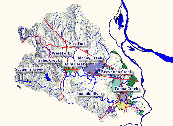
Back to Map |
| WEST FORK DAIRY CREEK |
| STREAM MILE INDEX |
| 2114003000480090 |
| Mile |
Description |
| 0.00 |
Confluence with East Fork Dairy Creek (02114003000480080) |
| |
Start of Dairy Creek RM 10.55 - (02114003000480) |
| 1.96 |
Evers Road Bridge (CR A-187) |
| |
Rated Staff Gage for Stream Flow |
| 2.09 |
Lousignant Canal (RB - 02114003000480090010) |
| 2.82 |
State Highway 47 Bridge |
| 5.28 |
Greenville Road Bridge (CR A-159) |
| 6.20 |
State Highway 6 Bridge |
| 6.22 |
Cedar Canyon Creek (RB - 02114003000480090110) |
| 7.53 |
Cedar Canyon Road Bridge (CR 1938) |
| |
City of Banks to SE |
| 7.70 |
State Hwy 47 Bridge - Rated Staff Gage for Stream Flow |
| |
Discontinued USGS Gage 14205000 (10/40 to 9/43) |
| |
West Fork Dairy Creek at Banks, OR (drainage area 47.5 sq mi) |
| 7.72 |
Port of Tillamook Bay RR Bridge |
| 9.30 |
US Highway 26 Bridge |
| 10.60 |
NW Green Mountain Road Bridge (CR 127) |
| 11.02 |
Garrigus Creek (LB - 02114003000480090180) |
| 12.19 |
NW Turk Road Bridge (CR 233) |
| 12.36 |
Kuder Creek (RB - 02114003000480090190) |
| 12.90 |
NW Pihl Road Bridge (CR 1045) |
| |
Community of Manning |
| 13.33 |
Port of Tillamook Bay RR Bridge |
| Mile |
Description |
| 13.48 |
Port of Tillamook Bay RR Bridge |
| 13.58 |
Witcher Creek (LB - 02114003000480090200) |
| 14.37 |
Port of Tillamook Bay RR Bridge |
| 14.50 |
US Highway 26 Bridge |
| 15.00 |
NW Fisher Road Bridge (CR 394) |
| 15.11 |
Mendenhall Creek (LB - 02114003000480090220) |
| 15.58 |
Burgholzer Creek (RB - 02114003000480090230) |
| 15.60 |
US Highway 26 Bridge |
| 16.00 |
Community of Buxton - r mile east |
| 17.02 |
Williams Creek (LB - 02114003000480090240) |
| 17.98 |
Cummings Creek (RB - 02114003000480090250) |
| 18.10 |
State Highway 47 Bridge |
| 18.85 |
Port of Tillamook Bay RR Bridge |
| 22+ |
Headwaters |
Back to Map |
| McKAY CREEK |
| STREAM MILE INDEX |
| 2114003000480020 |
| |
| Mile |
Description |
| 0.00 |
Confluence with Dairy Creek at mile 2.26 - (02114003000480) |
| 1.31 |
Padgett Road Bridge (CR 2245) |
| 2.25 |
Hornecker Road Bridge (CR 2393) |
| |
Rated Staff Gage for Stream Flow |
| 2.30 |
Southern Pacific RR Crossing |
| 4.32 |
Glencoe Road Bridge (CR A-146r) |
| |
Rated Staff Gage for Stream Flow |
| 4.46 |
BPA Transmission Line Crossing |
| 5.34 |
Waible Creek (LB - 02114003000480020040) |
| 6.30 |
NW Old Scotch Church Road Bridge (CR A-66) |
| 8.00 |
US Hwy 26 Bridge - Sunset Highway |
| 9.36 |
NW West Union Road Bridge (CR 2496) |
| |
City of North Plains to West |
| 9.38 |
Southern Pacific RR Crossing |
| 10.94 |
Jackson Creek (LB - 02114003000480020100) |
| 12.80 |
NW Shadybrook Road Bridge (CR A-110) |
| 15.56 |
NW Collins Road Bridge (CR 1889) |
| |
Rated Staff Gage for Stream Flow |
| 16.56 |
Brunswick Canyon (RB - 02114003000480020179) |
| 16.66 |
EF McKay Creek (LB - 02114003000480020180) |
| 24.0+ |
Headwaters |
Back to Map |
| GALES CREEK |
| STREAM MILE INDEX |
| 2114003000560 |
| Mile |
Description |
| 0.00 |
Confluence with Tualatin River - (0211400300) |
| |
ISWR C-59523 5/25/66 |
| 1.63 |
Southern Pacific RR Bridge |
| 1.75 |
Forest Grove Bypass Bridge - State Highway 47 to State Highway
8 |
| 2.36 |
State Highway 47 Bridge |
| |
Gales Creek Recording Stream Gage |
| 3.66 |
Ritchey Road Bridge (CR 461) |
| 6.53 |
Prickett Creek (RB-02114003000560090) |
| 6.98 |
Stringtown Road Bridge (CR A-176) |
| 7.70 |
Roderick Creek (RB-02114003000560110) |
| 8.56 |
Roderick Road Bridge (CR 395) |
| |
Former USGS Gage 14204500 (10/40 to 9/56 & 10/70 to 9/81) |
| |
Gales Creek near Forest Grove Oregon |
| 8.94 |
Godfrey Creek (RB-02114003000560130) |
| 9.22 |
Kelly Creek (LB-02114003000560120) |
| 10.68 |
Clear Creek (RB-02114003000560150) |
| 11.44 |
Iler Creek (RB-02114003000560170) |
| 11.46 |
NW Gales Creek Road (CR 1312) |
| |
Community of Gales Creek |
| 11.47 |
Fir Creek (RB-02114003000560190) |
| 12.00 |
ISWR C-59509 5/25/66 above this point |
| 12.36 |
Clapshaw Hill Road Bridge (CR 2037) |
| |
Rated Staff Gage for Stream Flow |
| 12.40 |
Little Beaver Creek (LB-02114003000560200) |
| |
ISWR C-59512 5/25/66 |
| 12.92 |
Parson Road Bridge |
| 14.44 |
White Creek (RB-02114003000560210) |
| 14.68 |
NW Wilson River Highway Bridge (State Highway 6) |
| 15.74 |
Lyda Creek (RB-02114003000560230) |
| 16.26 |
Bateman Creek (RB-02114003000560250) |
| 17.50 |
Former USGS Gage 1420400 (10/35 to 9/45 & 10/63 to 9/70) |
| |
Gales Creek near Gales Creek, OR |
| 18.00 |
Beaver Creek (LB-02114003000560280) |
| |
Community of Glenwood |
| |
ISWR C-59524 5/25/66 |
| 18.45 |
NW Timber Road Bridge (CR 374) |
| 18.65 |
Wilson River Highway Bridge (State Highway 6) |
| 19.70 |
Wilson River Highway Bridge (State Highway 6) |
| 19.88 |
Coffee Creek (LB-02114003000560300) |
| 20.07 |
Finger Creek (LB-02114003000560305) |
| 20.70 |
South Fork Gales Creek (RB-02114003000560310) |
| |
ISWR C-59514 5/25/66 |
| 21.60 |
North Fork Gales Creek (LB-02114003000560320) |
| |
ISWR C-59513 5/25/66 |
| 22.76 |
Low Divide Creek (RB-02114003000560330) |
| |
Gales Creek Forest Park |
| 23.20 |
USGS Gage 14203750 (7/94 to ) |
| |
Gales Creek near Glenwood, OR |
Back to Map |
| TUALATIN RIVER |
| RIVER MILE INDEX |
| -211400300 |
| Mile |
Description |
Drainage Area
square miles |
Elevation
feet - 0.00 gage datum |
| 0.00 |
Mouth of Tualatin River at Willamette River |
712 |
|
| |
River Mile 28.5 (LB Willamette) |
|
|
| 0.20 |
Weiss Bridge- Petes Mtn Rd. |
|
|
| 1.60 |
Fields Creek (RB-02114003000010) |
|
|
| 1.69 |
State Hwy 212 Bridge (Fields Bridge) |
|
|
| 1.75 |
West Linn Stream Gage Station - LB |
|
|
| |
(USGS #14207500) |
706 |
85.61 |
| 2.40 |
Tate Creek (LB-02114003000020) |
|
|
| 3.45 |
Lake Oswego Corp. Diversion Dam |
|
|
| 4.25 |
Interstate 205 Bridge |
|
|
| 4.56 |
Wilson Creek (LB-02114003000080) |
|
|
| 5.34 |
Boat Launch -LB |
|
|
| 5.36 |
Shipley Creek (LB-02114003000100) |
|
|
| 5.38 |
Shipley Bridge- Stafford Rd. |
|
|
| |
(NWS Wire Weight Gage) |
|
|
| 5.62 |
Pecan Creek (LB-02114003000120) |
|
|
| 6.02 |
Athey Creek (RB-02114003000123) |
|
|
| 6.70 |
Saum Creek (RB-02114003000130) |
|
|
| 6.70 |
Oswego Canal Diversion (LB; River Elevation Recording Gage #14206990,
|
|
|
| |
Headgate, and Canal Recording Gage #14207000) |
|
|
| 7.36 |
Boat Launch - LB (Dogwood Drive) |
|
|
| 7.67 |
Browns Ferry Park Canoe Launch - RB |
|
|
| 7.83 |
Clackamas/Washington Counties Line |
|
|
| |
(Underground Cable Crossing Sign) |
|
|
| 8.18 |
Interstate 5 Bridge |
|
|
| 8.60 |
Boones Ferry Road Bridge |
|
|
| 8.64 |
Hedges Creek (RB-02114003000150) |
|
|
| 8.90 |
Tualatin Park Boat Launch (RB) |
|
|
| 8.91 |
Southern Pacific RR Bridge |
|
|
| |
Tualatin River at Tualatin Elevation Recording Station (#14206960)
- RB |
|
|
| 9.32 |
Fanno Creek (LB-02114003000180) |
26.8 |
|
| |
(Index available) |
|
|
| 9.33 |
Durham Treatment Plant Outfall (LB) |
|
|
| 9.34 |
Oregon Electric RR Bridge |
|
|
| 9.80 |
Cook Park Boat Launch LB) |
|
|
| 11.50 |
US Hwy. 99W Bridge (Pacific Highway) |
|
|
| |
Canoe Launch - LB (access from southeast of bridge) |
|
|
| 12.68 |
Overhead BPA Transmission Line; Vancouver-Eugene |
|
|
| 12.80 |
Rivermeade Boat Launch (Private) - LB |
|
|
| 15.20 |
Rock Creek-South (RB-02114003000250) |
13.7 |
|
| 15.50 |
Chicken Creek (RB-02114003000270) |
|
|
| 16.09 |
Chicken Creek Drainage Ditch (RB) |
|
|
| 16.22 |
Shamberg Bridge (Elsner Road) |
|
|
| |
Rated Staff Gage for Stream Flow - RB |
|
|
| 21.12 |
Overhead BPA Transmission Line; Big Eddy-Keeler |
|
|
| 26.90 |
State Hwy. 210 bridge (Scholls) |
|
|
| 28.20 |
McFee Creek (RB-02114003000310) |
|
|
| 30.76 |
Unnamed Stream (LB-02114003000320) (Jacktown) |
|
|
| 31.62 |
Burris Creek (RB-02114003000330) |
|
|
| 31.92 |
Christensen Creek (RB-02114003000350) |
|
|
| 33.30 |
Harris Bridge (State Highway 208) |
|
|
| |
Farmington Recording Stream Gage (#14206500) - LB |
568 |
100.42 |
| 35.68 |
Butternut Creek (LB-02114003000380) |
|
|
| 37.38 |
Gordon Creek (LB-02114003000400) |
|
|
| 38.08 |
Rock Creek Treatment Plant Outfall (LB) |
|
|
| 38.09 |
Rock Creek (LB-02114003000420 |
74.6 |
|
| |
Beaverton Creek (LB-02114003000420060) |
36 |
|
| 38.44 |
Rood Bridge Small Watercraft Launch - LB |
|
|
| |
Rood Bridge Road Bridge |
|
|
| |
Recording Stream Gage (#14206440) - LB |
|
105.16 |
| 40.44 |
Davis Creek (RB-02114003000430) |
|
|
| 41.64 |
Minter Bridge Road Bridge |
|
|
| 43.88 |
Jackson Slough (LB) |
|
|
| |
Jackson Bottom Wetlands |
|
|
| |
Hillsboro Treatment Plant Effluent Outfall (LB) |
|
|
| 44.40 |
State Highway 219 Bridge |
|
|
| |
Rated Staff Gage for Stream Flow - RB |
|
|
| 44.73 |
Dairy Creek (LB-02114003000480) - index available |
226 |
|
| |
Mckay Creek (LB-02114003000480020) - index available |
63.4 |
|
| |
East Fork Dairy Creek (02114003000480080) - index available |
|
|
| |
West Fork Dairy Creek (02114003000480090) - index available |
|
|
| 51.54 |
Golf Course Road Bridge |
|
|
| |
Golf Course Recording Stream Gage (#14204800) - RB |
|
|
| 53.74 |
LaFollett Road (Bridge removed) |
|
|
| 55.24 |
Forest Grove Treatment Plant Outfall |
|
|
| |
Fern Hill Wetlands |
|
|
| 55.32 |
Fernhill Road Bridge |
|
|
| 56.10 |
Springhill Pump Plant Intake |
|
|
| 56.80 |
Gales Creek (LB-02114003000560) - index available |
78.6 |
|
| 57.38 |
Carpenter Creek (LB-02114003000580) |
|
|
| 57.84 |
Dilley Creek (LB-02114003000600) |
|
|
| 58.04 |
Johnson Creek (LB-02114003000602) |
|
|
| 58.82 |
Springhill Road Bridge |
|
|
| |
Tualatin River at Dilley Stream Gage (LB) |
125 |
147.57 |
| |
(USGS 14-2035.00) |
|
|
| 59.02 |
O'Neil Creek (LB-02114003000620) |
|
|
| 60.00 |
Scoggins Creek (LB-02114003000640) - index available |
|
|
| 60.80 |
Wapato Creek (RB-02114003000670) |
|
|
| |
Wapato Creek Improvement District Return Flow |
|
|
| 62.00 |
Wapato Improvement District Headgate (RB) |
|
|
| 62.24 |
Southern Pacific RR Bridge |
|
|
| 62.25 |
State Highway 47 Bridge (Gaston) |
|
|
| 62.30 |
Bates Road Bridge |
|
|
| 62.80 |
Black Jack Creek (LB-02114003000700) |
|
|
| 62.90 |
Overhead BPA Transmission Line; Forest Grove-McMinnville |
|
|
| 63.13 |
TVID Patten Valley Pump Station Outfall #1 |
|
|
| 63.87 |
Tualatin River at Gaston Recording Stream Gage |
48.5 |
|
| |
(14202500) - RB |
|
|
| 64.26 |
TVID Patten Valley Pump Station Outfall #2 |
|
|
| 65.34 |
Williams Canyon (RB-02114003000730) |
|
|
| 65.90 |
Mt. Richmond Road Bridge |
|
|
| 67.30 |
Hering Creek (LB-02114003000760) |
|
|
| 67.83 |
South Road Bridge (Cherry Grove) |
|
|
| 68.44 |
"Roaring Creek (RB-02114003000790) " |
|
|
| 69.42 |
Little Lee Falls |
|
|
| 70.70 |
Raines Bridge- Tualatin River below Lee Falls |
|
|
| |
Rated Staff Gage for Stream Flow (LB) |
|
|
| 71.07 |
Lee Falls |
|
|
| 73.28 |
Haines Falls |
|
|
| 73.30 |
City of Hillsboro Haines Falls Intake - LB |
|
|
| 74.00 |
Lee Creek (LB-02114003000860) |
|
|
| 74.05 |
Patten Creek (RB-02114003000870) |
|
|
| 75.70 |
Sunday Creek (LB-02114003000900) |
|
|
| 76.60 |
Maple Creek (LB-02114003000940) |
|
|
| 76.95 |
Ki-A-Cut Falls |
|
|
| 78.00 |
Barney Reservoir Aqueduct Outfall (RB) |
|
|
| 79.3+ |
Headwaters of Tualatin River |
|
|
Back to Map |