Siuslaw National Forest
Siuslaw National Forest
4077 S.W. Research Way
P.O. Box 1148
Corvallis, Oregon 97339
(541) 750-7000
Fax: (541) 750-7234
TTY for hearing & speech impaired:
(Oregon Relay)
![]()
![]()
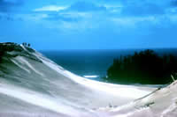
Geology of the Dunes
 The
Oregon Dunes are like no other dunes in the world. Desert-like landscapes,
lakes, rivers, ocean, and forest blend together, creating diverse ecosystems
of plants and animals
The
Oregon Dunes are like no other dunes in the world. Desert-like landscapes,
lakes, rivers, ocean, and forest blend together, creating diverse ecosystems
of plants and animals
Managed by the USDA Forest Service, this is the only part of the Oregon coast covered by extensive sand dunes. The sand dunes were formed by wind, water, and time.
Why Sand?
The sand in the Oregon Dunes is from the Coast Mountain Range, which is sedimentary rock that was uplifted 12 million years ago. As rock was moved downstream by rivers, it tumbled and abraded itself into sand.
The present shoreline stabilized 6,000 years ago. Tides, wave action and strong coastal winds moved sand up to 2.5 miles inland for thousands of years. This area of dune development rests on a gently-sloping terrace of solid marine sandstone called the Coos Bay Dune Sheet. This low rock surface stretches 56 miles from Heceta Head to Cape Arago and contrasts with steep headlands found on most of the Oregon coastline which prevent inland movement of sand.
Wind
Winds are a major influence in dune formation. Summer winds blow steadily from the north and northwest at 12-16 miles per hour. Mountain barriers near the coast deflect wind currents, sculpting the sand info many different shapes.
In winter, winds are generally lighter; however, they can exceed 100 miles per hour during intense winter storms. These winds blow from the south and southwest moving large amounts of sand. Seasonal changes in wind direction reshape dune sculptures and ridges.
Water
Water influences dune formation. Strong ocean currents flowing north in winter and south in summer hold sediment from rivers near the shore. Currents, tides and wave action dredge sand from the ocean floor and deposit it on the beaches where the wind takes over.
Sand absorbs and stores a large part of the annual rainfall. Where winds have removed sand down to the water table, plants have flourished. In the wet winter, the rising water table creates marshy areas with standing water several feet deep. With the upward pressure of water, the sand grains become more saturated and may float, resulting in quicksand. Look for quicksand in low, unvegetated areas between the dunes.
Shaping the Sand
 Wind and water are the two strongest forces shaping dune formation.
Summer winds blow steadily from the north and northwest at 12 to 16 miles
per hour. Mountain barriers near the coast deflect wind currents, sculpting
the sand into many different shapes. In winter, winds vary more; however,
they can exceed 100 miles per hour during intense winter storms. These
winds bow from the south and southwest, moving large amounts of sand.
Seasonal changes in wind direction reshape dune sculptures and ridges.
Strong ocean currents flowing north in winter and south in summer hold
sediment from rivers near the shore. Currents, tides and wave action
dredge sand from the ocean floor and deposit it on the beaches where
the wind takes over. Sand absorbs and stores a large part of the annual
rainfall. Where winds have removed sand down to the water table, freshwater
plants have flourished. In the wet winter, the rising water table creates
marshy areas with standing water several feet deep. With the upward pressure
of water, the sand grains become saturated and may float, resulting in
quicksand.
Wind and water are the two strongest forces shaping dune formation.
Summer winds blow steadily from the north and northwest at 12 to 16 miles
per hour. Mountain barriers near the coast deflect wind currents, sculpting
the sand into many different shapes. In winter, winds vary more; however,
they can exceed 100 miles per hour during intense winter storms. These
winds bow from the south and southwest, moving large amounts of sand.
Seasonal changes in wind direction reshape dune sculptures and ridges.
Strong ocean currents flowing north in winter and south in summer hold
sediment from rivers near the shore. Currents, tides and wave action
dredge sand from the ocean floor and deposit it on the beaches where
the wind takes over. Sand absorbs and stores a large part of the annual
rainfall. Where winds have removed sand down to the water table, freshwater
plants have flourished. In the wet winter, the rising water table creates
marshy areas with standing water several feet deep. With the upward pressure
of water, the sand grains become saturated and may float, resulting in
quicksand.
Geology Everywhere You Look
The Oregon Dunes are the largest expanse of coastal sand dunes in North America. Spend some time in the dunes, you are sure to see geology in action!
Here, the desert-like landscape blends with lakes, rivers, ocean and
forest, creating a diverse ecosystem filled with plants and animal. Day
to day, season to season this ecosystem can change dramatically.
From the Shore to the Forests - Take A Closer Look!
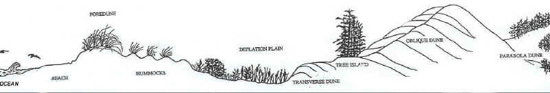
Beaches
Strong ocean currents, tides and wave action transport sand along the
sloping ocean floor. Smaller, lighter grains of sand, mostly quartz and
feldspar, are carried inland by the winds. Heavier grains of sand remain
on the beach. Offshore, the sand is 80 to 170 feet deep.
Foredunes
The foredune is a low hill, formed parallel to the ocean edge. Consisting
of sand and driftwood, the 25 to 50 foot high foredune is capped by European
Beachgrass, an introduced plant species.
Hummocks
Hummocks are immediately inland from the foredune. These knob-like mounds
are created by sand accumulation around vegetation. When the water table
rises in the winter, puddles may surround the hummocks and they appear
to be floating islands.
Deflation plains
The foredune separates the beach from inland areas.
Winds strip away the sand east of the foredune, deflating the area down
to the permanently
wet sand. This creates a deflation plain where water-loving vegetation
thrives. As the dunes move eastward, the plants of the deflation plain
also spread eastward.
Transverse dunes
The northwesterly winds of summer create wave-like patterns
called transverse dunes. The crests of these 5 to 20 foot high dunes
are perpendicular
to the wind direction. Changes in wind direction create the interesting
and unusual rides, although strong winter winds from the southwest tend
to smooth out these dunes. As the deflation plain expands eastward, so
do the transverse dunes.
Tree islands
Floating in the sand, these islands are small isolated remnants
of older coastal forests that were almost completely buried by sand.
The islands
are proof that moving sand is capable of burying whatever is in its way.
Steep slopes make the tree islands unstable and susceptible to erosion.
Oblique dunes
Oblique dunes are the largest and most spectacular dunes.
Occurring in parallel series, these dunes can rise to heights of 180
feet with
lengths up to a mile. Some oblique dunes are nearly 500 feet above sea
level. "Oblique" refers to the slanted angle at which both
summer and winter winds hit these dunes.
Oblique dunes move constantly, making it impossible for vegetation to grow on them. The west side of an oblique dune consists of a long, sloping ridge. The east side is usually higher and steeper, forming a precipitation ridge. In winter, the southwesterly winds create freestanding sculptures call yardangs. These unusual carvings can reach 15 feet high.
The Umpqua Dunes trail provides access to the best example of these dunes.
Parabola dunes
Winds create "blowouts" in some unstable areas
of the coastal forest. Strong winds erode the vegetation-covered surface
to bare sand.
Once a section has eroded, wind carries the sand further downwind, creating
characteristic U-shaped ridges call parabola dunes.
Transition forests
The transition forest is where the ocean-based ecosystem
changes to a land-based ecosystem. The interactions in this zone between
plants,
animals, wind, temperature, rainfall, sand and fresh and saltwater are
unique to this area.
Estuaries
Estuaries are where fresh river water meets salt water. As
ocean tides rise, organic matter and nutrients from both areas pool together,
creating
one of the most fertile environments in the world. These nutrients stimulate
the growth of plankton and other organisms, providing food form many
plants, fish, birds, and mammals.
Coastal Lakes
Lakes abound in the Oregon Dunes. Some of the 32 lakes
were once mountain streams that were dammed by sand. Others were ocean
inlets that were
cut off. Still others were formed when depressions in the sand filled
with water as the water table rose.
Over the years, several lakes have been buried by sand or dried up.
USDA Forest Service, Siuslaw National Forest
Last modified Wednesday, March 10 2004