 |
 |
|
| Home |
About the Project |
Tagging |
Habitat |
Fishes of Great Bay |
Teachers |
Kids |
Adopt A Fish |
Glossary |
Related Links |
Tracking Summer Flounder in an Estuary Creek: A WebQuest for 5-8th Grade (Biology)
Age-0 summer flounder, Paralichthys dentatus were tagged and tracked at Schooner Creek, a sub-tidal creek located in an estuary in Southern New Jersey. Stationary and mobile hydrophone systems were used to monitor fish movements. Data were accumulated over a one- month period. Your job as a young scientist is to analyze the data, draw some conclusions regarding the use of the creeks in the estuary by juvenile flounder, and make recommendations to local officials who are considering designating the area as a reserve.
How important is the estuary creek habitat for the growth and survival of juvenile summer flounder? Over-population near the Jersey coast and non-point source pollution may be affecting this habitat. Previous studies have shown that important nursery areas within southern New Jersey estuaries are marsh creeks, where Age-0 summer flounder forage and grow quickly during summer before migrating out to deeper water in the fall. Scientists have been hired to collect data by tagging and tracking Age-0 summer flounder during late summer/early fall. The data were collected and put into spreadsheets and graphs. Your task is to:
Working individually you will:
To Think About:In this section you will use www.crssa.Rutgers.edu to view a map and learn about the Jacques Cousteau National Estuarine Research Reserve (JCNERR), which is home to one of the largest estuaries in the NERR system. As you are navigating through, consider these questions: Why are estuaries so important? What is unique about this one? The Task
The QuestionsVisit this site a little longer to read about and see all of the components in the reserve, then try to answer these questions:
To Think AboutYou may be asking: So what's the big deal about Summer Flounder? Remember, you are young scientists with a mission. In this section, you are going to do some research to learn more about them. Some questions to consider as you research the Summer Flounder: Which parts of the estuary do they frequent and why? In what ways are flounder prepared and consumed by humans? The Task
The QuestionsUnder "More information," click on "Larvae" and other sections to learn more about this species. Then try to answer the following questions:
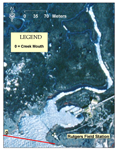
To Think AboutFor this portion of the process, you will read the following sections about the study as well as the study area. Keep in mind that you will print out the image below and draw in some points of detail. You can either right-click on the image to save it or copy it to another application, or you can CLICK HERE to download a PDF version of it.
Where the study was done and whySchooner Creek is a salty tidal creek that runs along side the JCNERR field station in the estuary. It was chosen as the site for this study because in a past tagging study at this site, large gaps of time left several unanswered questions regarding when the fish left and the extent of their creek use. The creek was divided into five sections based on depth and width, but we will be looking at three:
Now you can begin filling in points on your map, starting with the mouth, flat, upper creek, and the stationary hydrophone. TaggingFive summer flounder were captured using fyke (funnel type) nets approximately 150 meters up the from the creek mouth. Four were captured using hook and line near the tide station, which was approximately 350 meters up from the creek mouth. All nine of the fish were determined to be less than one year old based on information about size and age. (Here is some more information for your map.) They were tagged and released at different times. Each fish was temporarily put to sleep with an anesthesia and an ultrasonictransmitter was attached with a strong thin thread by sewing through the muscle just below the dorsal fin. The transmitters were manufactured by Sonotronics, Tucson, Arizona, weighed 4 grams in the air and had a 40-day life expectancy. So, there were 40 days, or about a month and 10 days to collect the data. It was the beginning of August. Since it wasn't known how the fish would recover from the tagging procedure, they were kept for observation in a flow-through seawater tank for about 1-48 hours. The release site was approximately 530 meters up the creek from the mouth. The tagging-release procedure began August 9, with the last fish tagged and released on August 27th. Fish movements were tracked until the last signal was lost on Sept. 27, 1990. TrackingA 150-meter coaxial cable connected the hydrophone to a continuously scanning receiver. After a signal is detected from a tagged fish, the tag number, time, and date were stored in a computer. After some testing, it was determined that the stationary hydrophone was good for approximately 130 meters directly in front of it. Sometimes a fish would swim back and forth in front of it making multiple detections, so multiple detections within 5 minutes were counted as one. The other way fish were tracked was by portable directional hydrophones from a small boat or kayak. Initial detection was recorded on a detailed map of the creek. Then the creek was searched every six hours during slack water. Slack water is the time just before a high or low tide when the current is minimal. If a fish had not been detected for a while, a search was on dividing the mouth and a short distance beyond in 1 KM transects or grids from the last known location. Transect searches were repeated three time before the signal was considered lost. A "missing" category accounted for the time it was known the fish was in the creek but could not specifically locate it. For example, if a particular fish was located at the mouth at 6:00am and in the upper creek at 12:00 pm, but did not detect it moving up the creek, 6 hours were placed in the "missing" category. Each time a fish was detected by the portable hydrophone, the time and stage of the tide was recorded as well as some physical and chemical data. The tide station was located 335 meters from the creek mouth. Surface salinity was measured with a refractometer, bottom temperatures and dissolved oxygen (DO) concentrations with a YSI meter. Important Note: you are going to have to explain what these things are when explaining your data The QuestionsNow that you have a better understanding of the study and it's whereabouts, answer the following questions:
To Think AboutIn this section, you are to read and interpret the resulting data from this study. Keep in mind that you'll be using this data. Click on the thumbnails below to view and download the data sheets that scientists produced from this study:
The Questions
Now use your data and the information you gathered about the flounder and the estuary to present your argument for designation as a research reserve. Think about this question as you are compiling your list: What steps can we take as responsible stewards on planet earth to be sure that this habitat is healthy and available to future generations of fishes?
Your paper must be three to five pages long and include the following:
Be proud of your work! Make it neatly typed and thorough.
The maximum points you can earn on the project are 120 to be beyond awesome. There are three sections in the scoring rubric.
The salt marsh is a very dynamic environment, yet many species of fish use its creeks as nurseries. Young fish need this unique habitat to grow before venturing out into the ocean. What steps can we take as responsible stewards on planet Earth to be sure that this habitat is healthy and available to future generations of fishes?
Szedlmayer, S.T. and Able, K.W. 1993. Ultrasonic Telemetry of Age-0 Summer Flounder, Paralichthys dentatus, Movements in a Southern New Jersey Estuary. Copeia,(3), pp. 728-736 Last updated on August 15, 1999. Based on a template from The WebQuest Page |


| Copyright © 2005 Rutgers University |