|
Albert Pyle
Photo Provided by Mike West
|
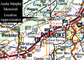
This marker was erected by the Veterans of Foreign Wars Post 5311 near
the plane crash site. The crash site is close to Roanoke, Virginia (see map
shown below for location). The gentleman in the photo is Mr. Albert Pyle,
who was assigned to Company B, 15th Infantry Regiment, 3rd Infantry
Division and served with Audie Murphy During World War II. Mr. Pyle
was with him when Audie was serioulsy wounded in the hip. After Audie's
death, Mr. Pyle wrote down his recollections of Audie which he gave to
Pamela Murphy. Mr. Pyle remembered, "Just before he was shot, he had
managed to capture a German non-com and his radio man. . . The
stretcher bearers picked Murphy up, but he still held a carbine across
his middle. Grinning, he directed his two prisoners ahead of him as
they made their way down the side of the hill. . . .This then was the
shy Audie Murphy, so badly wounded and still attempting to complete his
job, even though he is was in great pain."
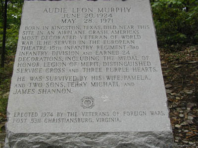
 Marker Inscription
Audie Leon Murphy
June 20, 1924 - May 28, 1971
Born in Kingston, Texas. Died near this site in an airplane crash.
America's most decorated Veteran of World War II. He served in the European
Theatre, 15th Infantry Regiment, 3rd Infantry Division and earned 24
Decorations including the Medal of Honor, Legion of Merit, Distinguished
Service Cross, and Three Purple Hearts.
He was survived by his wife Pamela and two sons Terry Michael and James
Shannon.
Erected by Veterans of Foreign Wars Post 5311, Christiansburg,
Virginia.
|
|
|
Inscription
Photo Provided by Fred Davis
|
Approximate Location
The site itself is located along a small leg of the Appalachian Trail which
travels over several peaks and saddles. The blue blazed trail behind the
monument leads to an overlook with excellent views of Sinking Creek Valley.
There is also a lovely bed and breakfast place about 30 miles away where you can
stay for the night. Owned and operated by Ray Batiato and Mary Virginia Haskins, its right smack on the Blue Ridge
Parkway at milepost 159.3. Visit the
Stonewall Bed and Breakfast for more details.

|
Route 624 Sign
Photo Provided by Fred Davis
|
To reach the site from the town of Blackburg, take Mainstreet to Mount
Tabor Road (also known as Route 624). Go 12 miles just past Route 650
and turn left onto a gravel road (FSP 188.1). You need to go 1.8 miles and
then turn right at the top of
Brush Mountain. Continue 1.6 Miles to the parking lot gate.

|
Sign at Main Gate and Parking Lot
Photo Provided by Fred Davis
|
You will come to a parking lot.
From here, you will have to hike about 7/10's of a mile to the memorial.
|
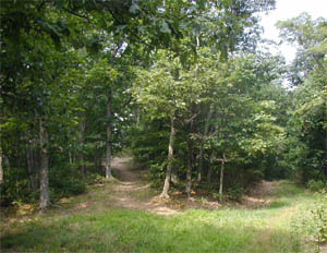
Fork In The Trail
Photo Provided by Fred Davis
|
After leaving the parking lot and entering the trail, you need to take the left path at the
fork.
|
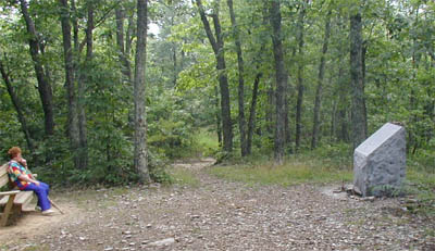
Memorial and Visitor's Bench
Photo Provided by Fred Davis
|
After a hiking less than a mile, you will come arrive at the marker if you stick to the trail.
There is a bench nearby you can rest at too.
MEMORIAL LOCATION
INFORMATION
|
| Road Distance: |
17 miles |
| Trail Difficulty: |
Easy |
| Hiking Distance: |
1.5 mile loop |
| Elevation: |
3100 feet |
| County Location: |
Craig & Roanoke Counties |
| Site Name: |
Brush Mountain |
Request
Information
Through: |
Blackburg Ranger Station
110 Southpark Drive
Blackburg, Virginia 24060 |
| Phone: |
(540) 552-4641 |
|
Directions and Location Information Provided by
Sue Gossett |
|