Kelly Barnes Dam Flood of November 6, 1977, near Toccoa, Georgia
by C.L. Sanders and V.B. Sauer
U.S. Geological Survey Hydrologic Investigations Atlas HA-613
1979
Introduction
The Kelly Barnes Dam on Toccoa Creek near Toccoa, Ga., failed at approximately 1:30 a.m., November 6, 1977, after a period of intensive rain. Thirty-nine people were killed and damages were estimated at $2.8 million by the Federal Disaster Assistance Administration and the U.S. Department of Housing and Urban Development (Roland Serabia and Carl Badger, oral commun., 1978).
Immediately after the flood, hydrologists of the U.S. Geological Survey obtained hydrologic information to document the disaster and to test the Survey's dam-break model procedures.
President Jimmy Carter, at the request of Governor George Busbee of Georgia, authorized the U.S. Army Corps of Engineers to make a technical assessment of the Kelly Barnes Dam failure with the assistance of other Federal agencies having appropriate expertise. The Corps of Engineers, the U.S. Geological Survey, the Soil Conservation Service, and the National Weather Service formed a technical Federal Investigative Board that conducted the technical assessment and published its evaluation as, Report of Failure of Kelly Barnes Dam, Toccoa, Georgia, in December 1977. The history of the dam and meteorological and hydrologic findings of the Board are repeated herein to complement the additional detailed hydrologic and hydraulic data presented in this atlas.
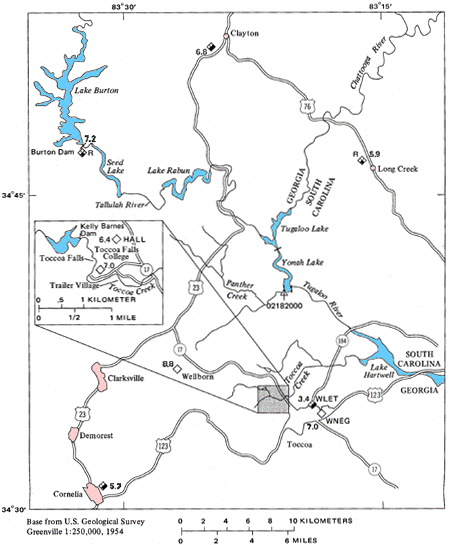
| EXPLANATION | |
|---|---|
| Discontinued U.S. Geological Survey gaging station | |
| Weather stations - Number is Nov. 2-6 rainfall total, modified from Federal Investigative Board (1977) and National Oceanic and Atmospheric Administration (1977) | |
| National Weather Service daily rainfall and temperature | |
| Private rainfall data and source | |
Figure 1. -- Location of report area and rainfall near Kelly Barnes Dam, November 2 - 6, 1977
Toccoa Creek Basin: Toccoa Creek lies immediately north of Toccoa, Ga., and flows in an easterly direction to Lake Hartwell (fig. 1). The drainage basin above the damsite has an area of 4.6 square miles and it is heavily wooded with pines and deciduous trees. The Toccoa Creek basin is in the Piedmont physiographic province and soils are of the Pacolet-Wedowee-Chandler association, clay loam to loam subsoil. Stream channels are fairly steep and have slopes that generally exceed 100 feet per mile.
Between the dam and Toccoa Falls, the average low-water channel
width of Toccoa Creek is 40 feet. Below the falls the low-water
channel is about 50 feet wide and the flood plain ranges from 100
to 400 feet in width. The Toccoa Falls College trailer village
was located on the flood plain where the width is approximately
350 feet. The flood plain expands downstream from the trailer
village, but becomes restricted to a width of 200 feet upstream
from Georgia Highway 17.
Kelly Barnes Dam and Lake: Kelly Barnes Dam was about 400 feet long, 20 feet wide at the crest, and 40 feet high at the maximum section. The dam was concave upstream. Figure 2 shows the lakebed and the broken dam.
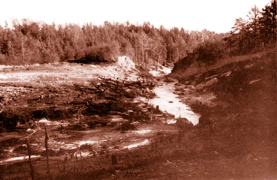
Figure 2. - Lakebed and remains of Kelly Barnes Dam.
(View downstream)
The history of the dam as determined by the Federal Investigative Board (1977) is summarized as follows: The dam went through various stages of development, first as a rock crib dam and then with subsequent stages as an earth dam. The rock crib dam was completed about 1899 to impound water for a small hydroelectric plant located near the foot of the falls. About 1937, the Toccoa Falls Bible Institute, which later became Toccoa Falls College, was interested in developing a more dependable power source and decided to build an earth dam over the rock crib dam with equipment provided by a local manufacturer. Figure 3 shows part of the rock crib dam and the penstock pipe to the powerplant that was incorporated in the new dam.
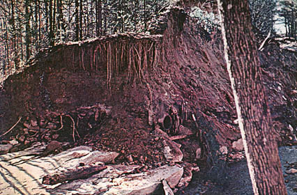
Figure 3. - Remains of rock crib dam and penstock pipe
exposed by breach in Kelly Barnes Dam. Log in foreground was part of rock
crib dam
After World War II, the earthfill was raised to a point where an earth spillway on the left side of the valley (facing downstream) could be utilized, and a low point on the rim on the right side away from the dam would serve as a secondary spillway during high flows. This installation served as a power source for the Toccoa Falls Bible Institute until 1957. At that time, power generation was stopped but the lake continued to be used for recreation.
The normal pool elevation for Kelly Barnes Lake was about 1,137 feet above NGVD (National Geodetic Vertical Datum of 1929). The lake had an impoundment of about 18 million cubic feet (410 acre-feet) and a surface area of about 42 acres. The maximum lake level reached before the dam failed was 1,141.6 feet, with an impoundment of about 27 million cubic feet (630 acre-feet). The elevation of the low point on the crest of the dam was approximately 1,147 feet, based on surveys of the remaining embankment after the failure.
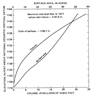
Figure 4. -- Relation of elevation to volume and to surface area of Kelly Barnes Lake |
The surface-area elevation and volume-elevation curves for Kelly Barnes Lake are shown in figure 4. Bench marks used for topographic surveys, high-water profiles, and cross sections are listed in table 1 and shown in figures 9 and 10. |
Topographic maps of the lakebed and the dam were prepared immediately after the break by the U.S. Geological Survey (figs. 5 and 6). The earth spillway at the left end of the dam (facing downstream) apparently carried all normal lake overflow. The crest of the spillway was 1,136.7 feet above NGVD (596.2 feet above datum). A low area, minimum elevation 1,139.8 feet (599.3 feet above datum), in the approach road about 1,100 feet upstream on the right rim, served as a secondary spillway.
![]() Figure 5. -- Bed of Kelly Barnes Lake after failure of
dam, November 6, 1977 (500x394 pixels, 64k, opens in new window)
Figure 5. -- Bed of Kelly Barnes Lake after failure of
dam, November 6, 1977 (500x394 pixels, 64k, opens in new window)
Larger image
(700x551 pixels, 96k)
![]() Figure 6. -- Kelly Barnes Dam
after failure (600x469 pixels, 116k, opens in new window)
Figure 6. -- Kelly Barnes Dam
after failure (600x469 pixels, 116k, opens in new window)
Larger image
(900x703 pixels, 200k)
The Federal Investigative Board (1977) concluded that separate inlets for a low-water spillway and a welded steel penstock to the powerplant existed at the time of the dam failure (fig. 7). These facilities were described by the Board as follows: "The low-level spillway had a rectangular shaped masonry inlet which could be shut off with stop logs or flashboards. The inlet for the welded steel penstock was also masonry and controlled with a slide gate at the upstream toe of the dam. . . . Some historical witnesses remember the penstock slide gate but do not recall the masonry structure. After the failure, this gate was retrieved from below the damsite and found to be closed. The conduits for the spillway outlet and new penstock were both welded plate pipes approximately 30 inches in diameter. A historical witness stated that during placement of fill over the spillway conduit, the pipe began to cave in and had to be reinforced with metal struts. . . . At this time, or during previous construction, the old spiral riveted penstock pipe had been abandoned, but not removed. Conflicting information suggests the possibility of a series of construction events during the 1940's. A 1954 Survey of Buildings, Roads, Streams, and Lakes of the Toccoa Falls Institute locates the overflow pipe (low-level spillway), 24-inch conduit (welded steel penstock), and the intake structures.

Figure 7. - Separate inlets for low-water spillway and
welded steel penstock to power plant, photographed in 1949. (Photograph
courtesy of Federal Investigative Board, Kelly Barnes Dam)
"Information available indicates that the fill was constructed to its final height in the late forties. However, a study of stereopairs of aerial photographs taken on January 17, 1955, shows the reservoir to be essentially empty at that time. The inlet structure, two earth spillways:, and the pipe leading to the powerhouse are clearly visible. In later years a heavy growth of vegetation became established on both the upstream and downstream faces and apparently obliterated the masonry intakes from view. Again, information received from historical witnesses conflicts as to whether or not two structures existed at the time of failure. Judging from the debris found downstream and the remains of the welded steel penstock, it is the Board's opinion that both existed at the time of failure."
The Federal Investigative Board (1977) reported:
"A number of observers informed the Board of seeing almost continual seepage on the downstream slope of the dam near the point of exit of the spillway pipe. Photographs obtained from one source, taken in 1973, show that a large embankment slide had occurred on the downstream face of the dam. . . . This 12-foot high, 30-foot wide slide of unknown depth, was observed on the lower one-third of the downstream slope in the area of the current failure section, which was the highest point of the dam. The slide left a two-foot, vertical, scarp face and partially exposed the end of a pipe. The slide, at the time of the photograph, was apparently not recent because of the existence of established vegetation on the slide area. The picture shows the pipe to be essentially clogged with silt and trash, but a very slight seepage was observed coming from the pipe. The area near the pipe contained water that was discolored by iron oxide, sulfur, or some other matter indicating little or no flow. The area adjacent to the recent dam failure was wet and spongy a week after the failure and seepage water was still coming from the toe near the right abutment (looking downstream) at that time."
The Board also stated,
"The rock type at the site is a biotite gneiss of the Carolina gneiss series. . . . A layer of soft alluvium, from two to five feet thick [overlying solid bedrock] was observed in both faces of the breach of the dam. This material extends from the proximity of the old crib dam upstream - an undetermined distance. The layer appears to be quite extensive in the foundation of the earth dam. The lower six inches of the layer of the alluvium contains an extensive root mat. The alluvium appears to be composed principally of soft, plastic clay and (or) silt with some layers of fine silty sand."
Toccoa Flood
page or Water
Resources of Georgia
If you have questions or comments about this page, please send them to webmaster-ga@usgs.gov.
USGS Privacy Statement |
Disclaimer
The URL for this page is http://ga.water.usgs.gov/publications/ha613/index.html