|
|


Keyhole provides a unique perspective - turning your
mountains of disparate government data into, well,
mountains. And streams. And rivers, lakes, ports,
borders, highways, buildings, houses, cars all fused
into a life-like viewpoint.
The result? A whole new perspective on your world:
a simple, fast, fluid fly-through over terabytes of
data, speeding familiarization with an area and
uncovering previously unseen data relationships and threats.
-
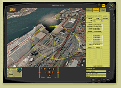
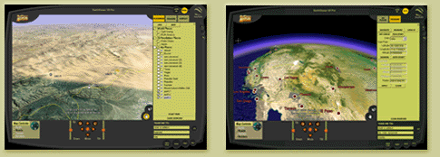
A 3D, Realistic Visualization: immersive 3D
rendering lets you rapidly view a contiguous
3D terrain at any angle, any elevation, surveying
potential risks and planning operations.
-
No GIS Experience Needed: superior ease of use
allows virtually anyone to view, grab, pan, and
zoom through earth imagery and GIS data in minutes.
-
A Mosaic of Government Data: Support for massive
databases of earth imagery (either ours or yours),
geographic data, and relational databases fuses the
full spectrum of data into one visual context.
|
Super Scalability
|
Unparalleled Performance
|
Massive Database Dissemination
|
|
With over 250,000 users supported in 2002, the
Keyhole EarthSystem is the only
network-delivered earth imagery and GIS system
proven to handle thousands of concurrent
users. |
The Keyhole EarthSystem uses a proprietary
compression/caching schema to enable fast,
fluid delivery of high-resolution imagery and
GIS data over the Internet and private
networks. |
The Keyhole EarthSystem supports
multiple-terabyte data clearinghouses; and has
proven this ability by network-delivering the
largest known collection of earth imagery and
data commercially available today (7+ TB).
|
State and Local Government
The power of aerial imagery has long been recognized
by State and Local governments. And Keyhole makes this
aerial imagery exponentially more powerful by
distributing it out of the back (legacy GIS) office and
into the hands of line of business managers:
departmental administrators and managers, city council
and representatives, planning commissions and zoning
boards, city inspectors and others with no GIS
experience necessary.
-
Emergency planning and first responders can
quickly familiarize themselves with an area,
including remote, mountainous locations
-
Zoning and land use management and planning can
see a proposed development with real world context
-
Economic development, Chambers of Commerce,
Convention and Visitors Bureaus can use
Keyhole's EarthViewer 3D as a marketing tool
-
Public libraries and museum kiosk installations
can give citizens access to their city from a
new perspective
Current customers include City of Ontario, CA.
Federal Agencies and NGO's
A variety of national and international government
organizations are finding the speed, ease of use,
and collaborative capabilities of the
Keyhole EarthSystem to be a more engaging visual
platform for decision support and analysis.
Federal Agencies
-
Environmental agencies monitoring various natural
assets and land use
-
Space research agencies for visualizing data from
Earth and other planets
-
Geological/Land Management agencies for fast,
fluid flythrough of their data clearinghouses
Current customers include the Department of Interior.
NGO's
-
Poverty rate visualization and understanding
of access to health care and technology
-
War/conflict mitigation and data dissemination
-
Environmental planning visualization at the
World Summit for Sustainable Development, August 2002
Current customers include the United Nations.
Homeland Defense/Military Intelligence
There's no shortage of homeland security data.
Terabyte upon terabyte of reports, research,
GIS data, relational databases, spreadsheets,
aerial images, maps, elevation data, business
listings, and much more.
Homeland Defense - A new perspective on domestic assets
and vulnerability to various threats.
-
Surveillance data pattern visualization
-
Critical infrastructure vulnerability assessment
and protection
-
First responder site familiarization, planning
Military Intelligence - Instant access to desired
views of massive aerial image libraries
-
Mission planning/training/simulation
-
Aerial imagery distribution to geographically
dispersed operations
For a demo on how to build your own digital earth
using the Keyhole EarthSystem, please contact
Andria Ruben, Government Sales Directory through our
Business Development form,
or 650-625-9400.
©2003 Keyhole Inc. Images,
©2003 I-Cubed, ©2003 AirPhotoUSA.
Maps © GDT Inc.
All rights reserved.
|
|
|