| On March 22, 2000, Mayor Anthony Williams brought together the 20 federal and District agencies that own or control land along the Anacostia River to sign the Anacostia Waterfront Initiative (AWI) Memorandum of Understanding (MOU). The AWI MOU created an unprecedented partnership between the federal and District governments to transform the Anacostia River from the city’s forgotten river to a gem that could rival any urban waterfront in the world.
Under the leadership of the District of Columbia Office of Planning, the partnership has produced a draft AWI Framework Plan to guide the revitalization effort. Additionally, 8 Target Areas within the boundaries of the AWI have been studied in detail, producing visions and plans that reflect the themes of the AWI. The Framework and Target Area plans have been developed in a public process over the last 3 years that has engaged more than 5,000 participants. Immerse yourself in the AWI Project Timeline; you’ll see just how close we really are to rediscovering the Anacostia Waterfront!
For more information, please select from the links below:
|
|
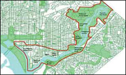
The AWI Boundary stretches from Southwest
Washington to the Maryland border
CLICK THE IMAGE TO ENLARGE
|