Main website navigation:
The National Archives has important holdings of military maps and fortification plans. They illustrate military and naval battles and operations from Tudor times, through Trafalgar and Waterloo, to the D-Day landings and the Korean War.

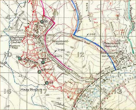
Large holdings of maps relate to the First World War, and these may be used in conjunction with other documents. Trench maps (in WO 297) show the opposing trench systems and enable you to identify places referred to in the British Army Unit War Diaries (in WO 95, some are in The National Archives DocumentsOnline).
For further detail, see the First World War: Military Maps research guide and the Military Maps of the Second World War research guide.
The Bomb Census maps (HO 193) show where German bombs fell on the United Kingdom in the Second World War. See our Maps, Bomb Census, 1940-1945 research guide.

The National Archives holds many charts, views and surveys made by naval officers (including Captains Grenvill Collins, Cook, Vancouver, Bligh and Nelson) and many plans of dockyards and naval defences. These date from a fourteenth century portolan chart of the Mediterranean, and show waters at home and overseas. The National Archives is not a place of deposit for successive editions of published. The best place to look would be the British Library![]() .
.
For more information see our Admiralty Charts and Maps research guide
The National Archives holds many maps of places overseas. These include countries which have at one time been British colonies or protectorates, and also areas in which Britain has had a commercial or strategic interest or where there have been diplomatic or military concerns.
Maps record exploration, colonisation, and the practicalities of running a global empire.

On a smaller scale, plans depict the sites and buildings that supported British expansion overseas such as fortifications, barracks, hospitals, consulates and governors’ residences.
See the Maps and Plans: Overseas Relations research guide for more.
The following catalogues have been published on overseas mapping in the series
Maps and Plans in the Public Record Office:
Volume 2. America and West Indies, ed P A Penfold (HMSO, London, 1974)
Volume 3. Africa, ed P A Penfold (HMSO, London, 1982)
Volume 4. Europe and Turkey, ed G L Beech (Stationery Office, London, 1998)
The National Archives holds maps, surveys and other records relating to international boundaries, principally for areas where British colonial interests were involved. Increasingly the boundaries between British colonies and neighbouring colonies of other European nations were defined by treaty and drawn on a map to be preserved among the archives of the colonial powers concerned.
The National Archives also holds maps and other records of boundary commissions for boundaries in which Britain had no direct territorial interest, where a British commissioner was invited to act as a neutral party. For more information see the International Boundaries: Maps and other documents research guide.