Located in the Caribbean Sea, the Netherlands Antilles (Nederlandse Antillen) cover a total area of 960 km²,
consisting of five main islands split into two widely separated units. Situated in the northeastern reaches of the
Caribbean are the Windward islands of Saint Eustatius (21 km²), Saba (13 km²), and Saint Martin (96 km²)
— the southern half (44 km²) of Saint Martin (known as Sint Maarten) is a Dutch territory, while the
northern section (52 km²) is a territory of the French Dependency of Guadeloupe. Lying off the Venezuelan
coast of South America, between 844 and 895 km southwest of Saint Martin, are the larger islands of
Curaçao (448 km²) and Bonaire (246 km²). The island
of Aruba (193 km²), located 77 km northwest of Curaçao, was part of the Netherlands
Antilles until succession in 1986 — it is now an autonomous territory of the Netherlands. Willemstad, on
Curaçao, is the seat of government.
NOTE: Due to the wide geographical separation of the northern and southern islands, only the Windward islands of Saba, Saint Eustatius and Saint Martin are dealt with in this section of the Atlas. Aruba, Bonaire and Curaçao have their own entries.
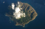
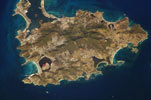
The northern islands of the Netherlands Antilles are located in the northeastern regions of the Caribbean, lying southeast of the Virgin Islands and northwest of Antigua. Saba and Saint Eustatius are the northernmost islands that lie upon the inner active volcanic arc of the Lesser Antilles — the arc extends from Saba, through Saint Eustatius, Saint Kitts, Nevis, Redonda, Montserrat to Basse Terre of Guadeloupe. Saint Martin, located to the northeast of Saba and Saint Eustatius, lies at the northern end of an older, extinct volcanic arc (known as the Limestone Caribbees) that includes Sombrero, Anguilla, Saint Barthélémy, Antigua, and Grande Terre of Guadeloupe. As a result of their younger ages, both Saba and Saint Eustatius have rugged mountainous interiors (rising to 870 m on Saba) bordered by coastlines of cliffs and steep slopes. The older Saint Martin, in contrast, has a lower profile consisting of low hills (422 m) and plains, with a coastline lined by sandy bays, salt flats, saline lagoons and with some coral reef development.
The Netherlands Antilles have a tropical maritime climate, with average temperatures ranging from 24°C to 32°C. Average annual rainfall of around 1,000 mm falls throughout the year and also in a short rainy season from October to January. Both temperature and rainfall are dependent upon altitude, with higher elevations being cooler and wetter. The islands are located within the Atlantic hurricane belt — on average one tropical storm or hurricane passes at a distance of less than 200 km each year with hurricane conditions occurring once every 4 or 5 years.