Cocos (Keeling) Islands
The Cocos (Keeling) Islands are an Australian External Territory lying in the northeastern regions of the Indian Ocean, situated 2,110 km northwest from the Exmouth Peninsula of Western Australia and 1,090 km southwest from the southwestern tip of Java. The closest neighbour to the islands is that of Christmas Island, located 950 km to the northeast. Note that the official name of the group includes "Keeling" in parenthesis. The islands consist of Cocos Atoll in the south and the small atoll of Palu Keeling located 27 km to the north, with a total land area of 14 km².
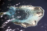
The largest, and only inhabited member of the group, is the atoll of Cocos. Measuring 15 km across, the atoll forms a horseshoe-shaped structure open on the northern side. The eastern and western sides of the reef contain 25 islands — the large elongate islands of West Island (Pulu Panjang), South Island (Pulu Atas) and Home Island, accounting for the signifcant portion of the atoll's land area. Situated outwith the main atoll ring and guarding the nothern entrance into the lagoon sits the solitary island of Palu Luar (Horseburgh Island).
The Cocos Atoll lagoon contains numerous "blue holes", intertidal sand, mud and coral flats, patch reefs and sand shoals. Extensively shallow, there is one lare deep basin to the center and north.
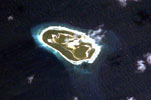
Palu Keeling (also known as North Keeling Island) is an uninhabited atoll lying 24 km to the north of the southern island group. The island takes the form of an almost closed ring surrounding a central shallow lagoon. The island is undisturbed and has been little changed since settlement of the southern atoll — and is now protected as the Palu Keeling National Park, providing sanctuary to thousands of seabirds.
The island measures 2 km by 1.3 km and consists of a ring-shaped strip of land no more than 400 m across encircling its central lagoon. The island itself is surrounded in turn by a fringing reef, except at the northwest corner. Low and flat, the islands outer shore rises quite steeply to 3-5m and then slopes gently down to the interior lagoon. On the northern shore there is a wide sandy beach, while the southern shore has a steep shingle beach. The central lagoon is very shallow (no more than 2 m in depth), and its entrance channel on the southeastern side of the atoll is practically blocked by a wide bar where the fringing reef passes the opening. The lagoon, which has a sandy floor and beds of sea grass, drains almost completely at low tide. Occasionally the channel becomes blocked leaving the lagoon cut-off from the open water. When this happens the lagoon shrinks until rough seas and storms reopen the channel.
The island is heavily vegetated, much of it with forests of Pisonia (Pisonia grandis) and Coconut (Coconut nucifera). Octopus bush (Argusia argentea), is common on the eastern shore. Around the margins of the lagoon Tea shrub (Pemohis acidula) thickets and stands of Ironwood (Cordia subcordata) are found.
The Palu Keeling National Park — declared in 1995 — is internationally important as a seabird rookery, with the dominant seabird species being the Red-footed booby — one of the largest breeding colonies in the world. The most outstanding natural feature is its status as a pristine coral atoll ecosystem. The atoll is an important seabird rookery. The most common bird is the Red-footed Booby (Sula sula) with an estimated population of 24,000 breeding pairs making the Palu Keeling one of the largest breeding colonies in the world. Also on the island are the Lesser Frigatebird (Fregata ariel) and the Greater Frigatebird (Fregata minor), Common Noddy (Anous stolidus) and White Terns (Gygis alba).