
Mozambique Channel
 The Mozambique Channel, located between Madagascar on the east and Mozambique on the west, forms an important
shipping route round the southern tip of Africa in to the Indian Ocean. The channel has a length of around
1,600 km and a width of between 400 and 1,000 km, reaching depths of up to 3,000 m. The channel plays host to
important ocean currents such as the Agulhas and Mozambique Current as well as being a breeding ground for
severe tropical cyclones.
The Mozambique Channel, located between Madagascar on the east and Mozambique on the west, forms an important
shipping route round the southern tip of Africa in to the Indian Ocean. The channel has a length of around
1,600 km and a width of between 400 and 1,000 km, reaching depths of up to 3,000 m. The channel plays host to
important ocean currents such as the Agulhas and Mozambique Current as well as being a breeding ground for
severe tropical cyclones.
The Mozambique Channel was formed when Madagascar began its separation from continental Africa during the break-up of the super-continent of Gondwanaland some 165 million years ago. In the mid-Eocene to the early Miocene the channel may have been spanned by a land bridge allowing terrestrial mammals to move between Madagascar and the mainland.
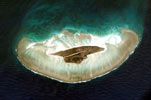
At the northern entrances of the Mozambique Channel occur a number of islands, reefs and submarine banks. The largest land masses in this area are those of the Comoros Islands. With an area of 2,170 km² this volcanic group consists of 4 main islands: Grande Comore, Nzwani, Mwali, Mayotte and numerous smaller islets that lie off the main islands.
Further in to the channel occur a trio of widely separated coral reefs and islands that form overseas possessions of France: Bassas da India, Juan de Nova and Île Europa. These islands are strategically important — their ownership is disputed between France and Madagascar. All are small, flat and uninhabited. The islets of Europa and Juan de Nova are important habitats for migrating landbirds and breeding seabirds.
Northwards, lying at the entrances in to the Channel, lie the French-owned Îles Glorieuses (Glorioso Islands) and the submerged reef of Banc du Geyser which lies in international waters.