Socotra Archipelago
 The linear chain of islands that form the
Socotra Archipelago are located in the northwestern regions of the Indian Ocean, lying east off the Horn of Africa
(the westernmost member of the group is located 95 km from the Somali coast) and 350 km south from the Arabian Peninsula
(see panoramic image). The islands from part of the Republic of Yemen. The group consists of
the main island of Socotra and the smaller islands of 'Abd al Kūri,
Samha and Darsa (the latter two known jointly as The Brothers; in
addition to the larger islands there are the small rocky outcrops of Ka'l Fir'awn and
Sābūnīyah.
The linear chain of islands that form the
Socotra Archipelago are located in the northwestern regions of the Indian Ocean, lying east off the Horn of Africa
(the westernmost member of the group is located 95 km from the Somali coast) and 350 km south from the Arabian Peninsula
(see panoramic image). The islands from part of the Republic of Yemen. The group consists of
the main island of Socotra and the smaller islands of 'Abd al Kūri,
Samha and Darsa (the latter two known jointly as The Brothers; in
addition to the larger islands there are the small rocky outcrops of Ka'l Fir'awn and
Sābūnīyah.
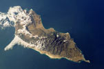
Socotra — the main island of the group — has an area of 3,625 km², measuring 132 km in length (from Ra's Shū'ab in the west to Ra's Momi in the east), with a maximum width of 35 km. It is the most easterly of the group, being located 240 km east of the Horn of Africa and 480 km south of the Arabian Peninsula. The interior of the island is composed of two important structural units: an extensive limestone plateau of Cretaceous age situated between 300 to 700 m above sea level and the rugged Hagghier Mountains in the east (rising to 1,519 m), which are composed of older metamorphic and granitic rocks. Surrounding the elevated interior are low coastal plains consisting of alluvial deposits of stone and sand as well as areas of dune field — with the premier example of this topography being the Nawqid Plain that stretches along much of the southern coast of the island. From the coastal plains the interior rises sharply in tall escarpments or receives the deep valleys and normally dry watercourses that descend sharply from the upland areas.
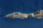
The minor islands of the archipelago total around 400 km². The most significant of these is the elongated island of 'Abd al Kūri, situated 105 km west of the cape of Ra's Shū'ab and 95 km off the tip of the Horn of Africa. The island has an area of 133 km², measuring 35 km in length and averaging 3 to 5 km in width. It consists of low-lying sandy plains and a series low hills rising to a height of 600 m. 47 km off the southwestern coast of Socotra is the 40 km² island of Samha, measuring 10 km by 5 km. Samha rises steeply from the shore to an unusual interior plateau. It's nearby neighbour of Darsa (16 km²) is situated 17 km to the east; with the two islands forming a pairing known as The Brothers. The most isolated of the minor islands are the twin sea stacks of Ka'l Fir'awn located 25 km north of 'Abd al Kūri (in the panoramic image they can be seen as a light blue area of water north of the western end of 'Abd al Kūri). Both consist of guano-covered rock rising to around 80 m in height. The final grouping comprises the rocky islets of Sābūnīyah (around 1 km²), located 10 km northwest of Ra's Shū'ab.
The Socotra Archipelago occupies an area of the arid tropics, having a climate modified by both its maritime position and by the seasonal monsoons of the Indian Ocean. From April to October the southwest monsoon brings hot and dry winds with occasional heavy rains from the African mainland. The northeast monsoon of winter (November to March) is somewhat cooler and wetter — although annual precipitation on the island is a scant 130-170 mm per year on the coast, rising to around 1,000 mm in the mountains. Mean average temperatures range from 27°C to 37°C maximum and 17° to 26°C minimum along the coastal plain, with temperatures being significantly cooler at higher elevations. The mountains of the interior are often shrouded in mist (as in the panoramic image at right) — providing a vital source of moisture to the islands unique floral communities.
The islands long history of geographical separation from mainland Africa and the Arabian Peninsula have allowed the islands flora and fauna to develop a high degree of endemism — particularly amongst plants and reptiles. It is perhaps best known for its unique plant life — 30% of plants are endemic to the islands and ten genera are unique to the islands.