Nauru

- STS111-E-5253
- 14 June 2002
- time unknown
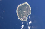
The solitary oceanic island of Nauru is situated in the western Pacific, located in an isolated position 285 km north-northwest from Banaba, 680 km southwest of the central Gilbert Islands and around 42 km south of the equator. The island forms the Republic of Nauru — one of the smallest (21.2 km²) and most isolated nations on Earth. Nauru is an example of a phosphate-rich, raised coral atoll. It is one of several premier examples of such formations to be found in the Pacific — the others being Makatea in the Tuamotu Archipelago, and the solitary islands of Banaba and Niue.
The island is approximately oval-shaped, measuring 6 km in length and 4 km across with a circumference of 18 km. From a narrow coastal belt of between 200 and 500 m in width, the terrain rises to an interior plateau averaging 25 to 50 m in elevation and reaching a maximum height of 71 m above sea level at Command Ridge. Upon the plateau are features that are thought to be remnants of the ancient atolls' lagoon — including the depression that today contains the small brackish Bauda Lagoon (12 ha) — features that may represent the former atoll rim and reef are also evident in small areas of high ground and ridges. The plateau is reached in a series of low vertical cliffs or gentle slopes (both marked by dark green vegetation cover in the image) and is a sparsely vegetated landscape dominated by the pits and pinnacles left behind from open-cast phosphate-mining activity. The coast of Nauru is completely surrounded by a shallow, intertidal fringing reef of between 100 and 300 m in width. The coast is unbroken except for the large Anibare Bay on the eastern side (bottom in the image).
Nauru is the emergent part of a seamount that rises over 4,000 m from the ocean floor below and that is perhaps 35 million years old. The seamount was at one time topped by an atoll formation (from 5 million to 300,000 years before the present), but has since been raised by tectonic activity to its present elevation. The coral limestone that caps the seamount has been shown to be over 500 m in thickness.