Scarborough Shoal

- Landsat 7
- Path 118 Row 050
- 23 February 2000
Scarborough Shoal (sometimes referred to as Scarborough Reef) is located in the eastern reaches of the South China Sea, situated 220 km west from the island of Luzon in the Philippines (see panoramic image), 553 km southeast from Bombay Reef in the Paracel Islands and 345 km northeast from the Spratly Islands; its nearest neighbour in the region is the small Truro Shoal, 180 km to the northwest.
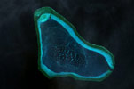
The reef is triangular in shape, covering an area of some 150 km², measuring roughly 19 km in length and 13 km in width. Scarborough Shoal is a sunken atoll formation consisting of a narrow reef rim, back reef slopes and a central lagoon that contains a deep basin towards the south. A single passage on the southeastern rim, 350 m in width, connects the interior with the open sea. With the exception of several coral rocks, the entire reef is submerged.
The reef is claimed by Philippines (due to its geographical proximity) and by the Chinese (for historical reasons) where it is known as Huangyan Island.