Earth
 | Go to Calendar page
|
|
| ,1 ,2 ,3 ,4 ,5 , 6 , | Go to HELP Page |
| Approx. Age: | 4.6 Billion Years |
| Average Distance From Sun: | 150 Million KM (1 AU) |
| Diameter: | 12,765 KM |
| Circumference: | 40,070 KM |
| Volume: | 10ą˛ KMł |
| Mass: | 5.977 X 10⁻²⁴ KG |
| Gravity: | 9.78 M/sec˛ |
| Atmosphere: | Nitrogen 78.09%; Oxygen 20.95%; Argon 0.93%; Carbon Dioxide 0.03% |
| Moons: | 5 - ( The Moon , Cruithne , 2003 yn107) |
| Earth Year: | 365 days 5hrs 48mins 46secs |
| Earth Day: | 23hrs 56min 4.1secs |
| Orbit Speed: | 30 KM/S |
| Population: | Approaching 6 Billion |
| Land Coverage: | 150 Million Sq KM |
| Water Coverage: | 361 Million Sq KM |
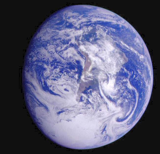
| The third planet from the Sun. | 70% of the Earth's surface (including the north and south polar icecaps) is covered with water. | |||||||||||||||||||||
| The most detailed portrait |
ever of the Earth's land surface is being created with ESA's Envisat environmental satellite. The GLOBCOVER project aims at producing a global land cover map to a resolution three times sharper than any previous satellite map.
| |||||||||||||||||||||
| The Earth is almost spherical, flattened slightly at the poles, and is composed of three concentric layers: the core, the mantle, and the crust. The crust and the topmost layer of the mantle form about 12 major moving plates, some of which carry the continents. The plates are in constant motion, called tectonic drift. When these plates rub together they cause EarthQuakes. | ||||||||||||||||||||||
| Astronomical Results |
The Earth is surrounded by a
life-supporting atmosphere and is the only planet on which life is known to
exist. This atmosphere also acts as a barrier, keeping out harmful radiation from the Sun.
This layer is however, being destroyed by toxic emissions from industrial
manufacture and energy production
| |||||||||||||||||||||
| Space Station Time in Orbit: |
Cumulative Crew Time in Orbit: |
|||||||||||||||||||||
| Geologists |
have added a `new period` to their official calendar of Earth's history.
Until recently the nature of the early ( Archean to Early Proterozoic) Earth crust was known mainly from studies of small continental relics dominated by granite, whereas the nature of the other ~90% of Earth crust remained unknown, except by indirect methods. The Ediacaran Period covers some 50 million years of ancient time on our planet from 600 million years ago to about 542 million years ago. It officially becomes part of the Neoproterozoic, when multi-celled life forms started to take hold on Earth. However, Russian geologists are unhappy their own title - the Vendian - which was coined in 1952, was not chosen. New geochemical evidence provided by ejecta fallout of large asteroid and comet impacts on the early Earth (2.4-3.5 Ga), preserved in sediments, indicate that the crust consisted largely of oceanic-type basaltic rocks, with small continental nuclei, and large transient impact basins (similar to the lunar Maria). | |||||||||||||||||||||
| With surprising and mysterious regularity, | life on Earth has flourished and vanished in cycles of mass extinction every 62 ± 3 million years. The pattern emerges from a computer study of fossil records going back for more than 542 million years, to the time of the `great Cambrian Explosion`, when almost all the ancestral forms of multicellular life emerged. Richard Muller and his graduate student, Robert Rohde, have published a report on their study of this cycle, in the journal Nature. "We've tried everything we can think of to find an explanation for These weird cycles of biodiversity and extinction and so far, we've failed." | |||||||||||||||||||||
| A new discovery | by a team of Queen's University scientists suggests that ancient earth was much colder than previously thought. The researchers discovered the mineral ikaite in 700-million-year-old marine sedimentary rocks in the Mackenzie Mountains of the Northwest Territories and eastern Yukon. This discovery proves that the ancient ocean was much colder than previously believed. Ikaite forms in shallow water on the sea bottom at cold temperatures. Overpopulation of ancient marine plants may have removed carbon dioxide from the atmosphere and created extreme cold that caused the earth's temperature to fall to form a `Snowball Earth` 700 million years ago | |||||||||||||||||||||
| 600 to 750 million years ago, | giant clouds in space may have led to global extinctions, according to two recently published technical papers.
One paper outlines a rare scenario in which Earth iced over during snowball glaciations, after the solar system passed through dense space clouds. Another proposes that a less dense giant molecular cloud may have enabled charged particles to enter Earth's atmosphere, leading to destruction of much of the planet's protective ozone layer. Both would resulted in global extinctions. This hypothesis can be tested by looking at Earth's rocks to find layers that relate to the snowball glaciations. Changes in the uranium 235/238-ratio in the layers would be proof interstellar material is present that originated from supernovae. Moderately dense space clouds are huge, and the solar system could take as long as 500,000 years to cross one.  to read more to read more | |||||||||||||||||||||
| Giant vortices |
found near Earth by Cluster satellites:
ESA's quartet of space-weather watchers, Cluster, has discovered vortices of ejected solar material high above the Earth. The superheated gases trapped in these structures are probably tunnelling their way into the Earth's magnetic "bubble," the magnetosphere. This discovery possibly solves a 17-year-mystery of how the magnetosphere is constantly topped up with electrified gases when it should be acting as a barrier. "These vortices were really huge structures, about six Earth radii across," These vortices are known as products of Kelvin-Helmholtz instabilities (KHI). They can occur when two adjacent flows are travelling with different speeds, so one is slipping past the other. to read more.
| |||||||||||||||||||||
| Using radio wave data from the Radio Plasma Imager | on the Imager for Magnetopause to Aurora Global Exploration (IMAGE) spacecraft, combined with archival data from the Dynamics Explorer spacecraft, scientists have solved the mystery of why the Van Allen Belt slot, or The safe zone, exists; Terrestrial Lightning, only a few miles above the ground, clears a safe zone in the radiation belts.
Radio waves generated by lightning interacting with the radiation belt particles, removing a little of their energy and changing their direction. This lowers the mirror point, the place above the Polar Regions where the particles bounce. Eventually, the mirror point becomes so low; it is in the Earth's atmosphere. When this happens, the radiation belt particles can no longer bounce back into space, because they collide with atmospheric particles and dissipate their energy. The safe zone appears as a gap between the inner and outer the Van Allen Belts, beginning about 7,000 km and ending about 13,000 km above the Earth's surface. to read more | |||||||||||||||||||||
| Geologists have long considered | sulfate, a common salt dissolved in seawater, as the key to determining how and when life evolved. On the ancient Earth, acquiring enough ocean sulfate measurements to accurately define the ecological conditions during evolution has been a serious challenge. Now, a novel method for extracting sulfate from ancient rocks has enabled a research team to uncover new evidence for sulfate levels in prehistoric oceans. to read more
| |||||||||||||||||||||
| Google Earth | ||||||||||||||||||||||
| ||||||||||||||||||||||
| Earthquake map |  
| |||||||||||||||||||||
| for forum
| ||||||||||||||||||||||
| For the first time, |
scientists have shown that highly precise measurements of Earth's ever changing gravity field can help to monitor changes in the planet's climate and weather.
This finding comes from more than a year's worth of data from the Gravity Recovery and Climate Experiment, or Grace. Grace measures, to one-hundredth the width of a human hair, changes in the separation of two identical spacecraft in the same orbit approximately 220 kilometers apart. "Observations of mass variations over the oceans will assist in interpreting annual signals in long-term sea-level change that have become an important climate change indicator," | |||||||||||||||||||||
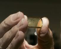
| Zircon crystal believed to be the oldest known piece of Earth dated at 4.4 billion years old. |
Discovered in Australia in 1984 by
Simon Wilde, professor at Curtin University of Technology in Perth, Western Australia
, this speck of zircon crystal is believed to be the oldest known piece of Earth.
Analysis of the object in 2001 by John Valley, a UW-Madison professor
of geology and geophysics concluded that the early Earth, instead of being a roiling ocean of
magma, was cool enough to have oceans and continents -- key conditions
for life.
Before its discovery, the oldest evidence for liquid water on the planet was from a rock estimated to be much younger -- 3.8 billion years old. to read more | |||||||||||||||||||||
| Astronomical Results |
Refine the Geological Time Scale:
A team led by Jacques Laskar from the Institut de Mecanique Celeste et de Calcul des Ephemerides (IMCCE) and the Paris Observatory have released new computational results for the long-term evolution of the orbital and rotational motion of the Earth. Following Milankovitch's theory of the paleoclimate that describes how major climatic changes on Earth are affected by astronomical events, these results have been employed to provide a new calibration of the sedimentary records over the 0 – 23.03 Myr geological period (the so-called Neogen period). The succession of the Ice Ages that occurred during the Pleistocene epoch (between 10 000 yrs and 1.8 million yrs (Myr) ago) has been shown to be related to the periodic changes of the Earth's orbit and rotational parameters. The variation of the Earth's orbital parameters regulates some of the major changes in the Earth's climate. to read more
| |||||||||||||||||||||
Return to Solar Database |


