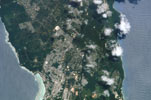
Guam

- ISS007-E-5421
- 13 May 2003
- 23:05 UTC
The largest, most populous, and southernmost island of the entire Mariana Islands chain, the island of Guam is located 58 km southwest from Rota and 184 km southwest from Saipan; the remote atolls of the Caroline Islands lie some 450 km to the south. Known officially as the Territory of Guam, the island forms an organized, unincorporated territory of the United States — the other islands of the Mariana Chain form the Commonwealth of the Northern Mariana Islands (CNMI).
At 541 km² in area, Guam is the largest island in the entire region of Micronesia. The island measures 48 km in length, orientated from north to south; average east to west widths across the island vary form 7 km in the centre to 15 km in the south.
Guam is built from two main structural units: the southern third consists of volcanic rocks, forming high hills cut by deep valleys, where a maximum elevation of 406 m above sea level is reached at the summit of Mt. Lamlam. The northern two-thirds of the island is a raised limestone formation.
image: earth sciences and image analysis laboratory, nasa johnson space center.