Mars
| Go to Calendar page
|
|
| Average Distance From Sun: | 227.8 Million KM |
| Temperature of Sunlit Side: | 0�C |
| Temperature of Dark Side: | -100�C |
| Atmosphere: | Very thin Carbon Dioxide gas |
| Diameter: | 6800 KM |
| Mass: | 0.11 Earth Standard |
| GRAVITY: | 0.5 Earth Standard |
| Moons: | 2, Phobos, Deimos |
| Mars Year: | 687 Earth Days |
| Mars Day: | 24hrs 37.5mins |
![]()
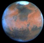
Mars is the fourth planet from the Sun and is commonly referred to as the Red Planet.Mars is slightly pear-shaped, with a low, level northern hemisphere, which is comparatively uncratered and geologically `young', and a heavily cratered `ancient' southern hemisphere.
Here is a full list of all the martian probes and space craft. The landscape is a dusty, red, eroded lava plain; red atmospheric dust whipped up by winds of up to 200 kph account for the light pink sky.Mars has white polar caps (water ice and frozen carbon dioxide) that advance and retreat with the seasons. There are four enormous volcanoes near the equator, of which the largest is Olympus Mons 24 km, with a base 600 km across, and a crater 65 km.No proof that life ever existed on Mars has been obtained.In July of 1965, Mariner 4, transmitted 22 close-up pictures of Mars. All that was revealed was a surface containing many craters and naturally occurring channels but no evidence of artificial canals or flowing water. The first human-made object to orbit another planet was Mariner 9. Viking 1 and 2, which landed, also provided much information. Studies in 1985 showed that enough water might exist to sustain prolonged missions by space crews. To the east of the four volcanoes lies a high plateau cut by a system of valleys some 4,000 km, up to 200 km wide and 6 km deep; these features are apparently caused by faulting and wind erosion. Mars is currently the object of scientific study with many probes either on their way or already orbiting Mars, one of these, the Mars Global Surveyor, is sending back the most detailed maps of the surface. One of the planned probes contains a microphone equipped landing module, allowing us, for the first time, to hear the sounds of an alien world. |
|||||
 for Forum for Forum
| |||||
| Up coming events | Mars shines like a star with a yellowish-orange hue. Mars will appear brightest in 2006 on New Year's Day, glowing brilliantly at magnitude –0.6 in the constellation of Aries and outshining all the stars in the sky with the exception of Sirius and Canopus. It will then be 72 million miles from Earth, but it will also be receding from us each night thereafter and hence will be getting progressively fainter. During the August 2003 appearance, when the planet came closer to Earth than it had in nearly 60,000-years. By March 1, it will appear more than 3½ times dimmer and by May 9 it will have fallen into the ranks of a second magnitude object. Mars will pass just over one-half degree from Saturn in the evening sky of June 17. A month later, it is all but gone from view, becoming too deeply immersed in the solar glare to be seen. It will be in conjunction with the Sun on October 23, becoming a morning object. Not until about the middle of December will it emerge from the bright morning twilight. to read more
| ||||
| The Mars Express spacecraft is currently orbiting the planet. Launched on an interplanetary voyage of exploration in early June, Mars Express carries with it the Beagle 2 lander, which was released from the Mars-Express `mothership` on December 19th. They reached Mars on December 25th, with Mars Express entering an elliptical orbit and Beagle 2 descending to the Martian surface. Two more invaders from Earth, NASA's Mars Exploration Rovers, arrived in January 2004. | |||||
|
|||||
| You can explore the Planet yourself: To boldly Go link: (JavaScript Application) Use the buttons/mouse to explore/zoom in anywhere on the interactive map of the surface of Mars. |
|||||
| The Mars Rover Exploration A (Mer-A), dubbed `Spirit`, landed on Mars, in the Gusev Crater, (15 degrees south of the Martian equator), at 0435 GMT Sunday 4 January, after a six-minute plunge through the Martian atmosphere. It sent back it`s first images of Mars within hours of arriving on the planet. `Opportunity` reached Mars three weeks later. |
|||||
| (Forums) |
|||||

|

| Mars Surface 4096x2048 | 821 Kb download.
|
| Mars Surface 8192x4096 | 13.3 Mb download. |
 |
|
Mar |
| A new study of five impact basins |
dotted along a giant arc around mars proposes where Mars' equator may have been long ago.
The five basins are Argyre, Hellas, Isidis, Thaumasia, and Utopia; they would have been created when a giant asteroid ,1000km in diameter, broke up and slamming into the planet. "The region near the present equator was at the pole when running water most likely existed� - Afar Arkani-Hamed of McGill University in Montreal. to read more (PDF) | |||
| Martian obliquity |
This explains the origin and existence of frozen water ice in the top meters of high latitudes near-surface (~60 deg - 90 deg) of both Martian hemispheres, observed by the Mars Global Surveyor and Mars Odyssey spacecrafts. When the obliquity overpasses 35� , the summer insolation becomes too strong to maintain the stability of the current Northern cap which provokes a quick atmospheric transfer of ice towards the equatorial high topography region of Tharsis (Arsia, Pavonis, Ascraeus et Olympus Montes). Remarkably, these summits present morphological traces which may be the result of the recent presence of glaciers. |
| The method used by planetary scientists to estimate the ages | of various regions of Mars is flawed. New findings by Nadine Barlow of Northern Arizona University in Flagstaff, will significantly change our understanding of when Mars may have been volcanically active. To estimate the age of any region on Mars, geologists count the number of meteor craters they can see in images of the area. The idea is that the older a surface, the more craters should have accumulated over time. Crater counts give an indication of the relative age of different Martian regions. To determine absolute ages, these counts are then compared with crater counts from regions of the moon, some of which have been precisely dated thanks to the rocks brought back by the Apollo astronauts. Assuming that the rate of meteor impacts at any given time was roughly uniform throughout the inner solar system, those ages should translate directly to Mars. Now it seems there is a fatal flaw in this method, at least when it is based on counts of very small craters. According to Barlow, recent infrared images taken by the Mars Odyssey spacecraft have unexpectedly revealed very long ray patterns around even relatively small craters, showing that much more material was ejected by meteor impacts than had been calculated. Massive plumes of ejected rock would have rained down to produce, in some cases, millions of secondary craters. It means the vast majority of craters smaller than 2 kilometres in diameter may be secondary craters, making them virtually useless for dating surfaces. Some crater-free areas on Mars have been estimated to be only about 150,000 years old. But based on the new findings, McEwen concludes that the age of such regions can only be pinned down to within 10 million years. And such uncertainty will remain until actual rock samples from Mars are dated. | |||
| The Interior of Mars | The current understanding of the interior of Mars suggests that it can be modeled with a thin crust, similar to Earth's, a mantle and a core. Using four parameters, the Martian core size and mass can be determined. However, only three out of the four are known and include the total mass, size of Mars, and the moment of inertia. Mass and size was determined accurately from early missions. The moment of inertia was determined from Viking lander and Pathfinder Doppler data, by measuring the precession rate of Mars. The fourth parameter, needed to complete the interior model, will be obtained from future spacecraft missions. With the three known parameters, the model is significantly constrained. If the Martian core is dense (composed of iron) similar to Earth's or SNC meteorites thought to originate from Mars, then the minimum core radius would be about 1300 kilometres. If the core is made out of less-dense material such as a mixture of sulphur and iron, the maximum radius would probably be less than 2000 kilometres.
| |||
| Topography Map of Mars |
Polar Laminated Terrain
One of the discoveries of the Mariner 9 spacecraft was that the south polar cap of Mars was made of thin layers or laminations of ice and sediment. Four years later, on October 10, 1976, the Viking 2 spacecraft took this picture of the Martian north polar cap. The visible layering occurred as a result of wind born dust settling upon the polar cap. As the caps experience climatic variations, they expand and contract. The layers of dust sediment tend to grow thicker near the poles where ice deposits remain for longer periods of time. The thickness of the deposits indicates they were formed during cyclical climatic variation rather than annual changes. As ice withdraws from a region, wind exposes the layers sculpting valleys and scarps. The formation of layered deposits is an active process today. | |||
| Mars's North Pole
|
is a record of the planet's climate over the past 3 million years.
The climate history is recorded in the light and dark bands seen on the sides of ice cliffs. Scientists now say that they can interpret these bands in the same way as `counting tree rings`. The bands seem to recur roughly every 30 metres through the ice, and caused by wobbles in the planet's orbit that happens every 51,000 years. The researchers also found that they indicate an 'interglacial period' occurred between 2.1 million and 2.7 million years ago. Where the banding pattern is missing from a 100-metre section of the ice, which corresponds to a period between 0.5 million and 2 million years ago, that maybe evidence for an 'ice age'. Another pattern `disappearance` possibly corresponds to the end of another ice age between 3 million and 4 million years ago. to read more | |||
| MOLA (cylindrical projection) |
 | |||
| Geology (Composited with MOLA data) |
 | |||
| "Crater" Martian highlands (wmv) "Canyonlands" Valles Marineris (wmv) "Crater" Martian highlands (rm) "Canyonlands" Valles Marineris (rm) | ||||
| A Ph.D. student |
at Virginia Tech has research published that shows Mars probably had liquid water at some point, but likely for only a short time
The Mars Rover Opportunity recently found the mineral jarosite, and using a computer-modeling program it was determined that it formed in acid mine drainage environments as sulphide minerals oxidize, or while volcanic rocks were being altered by acidic, sulphur-rich fluids near volcanic vents. As such, jarosite formation is thought to need an oxidizing and acidic environment and only forms when a small amount of reaction has occurred and completely decomposes if more water is available. "This shows that the reaction on Mars ran out of water. Either there was not enough water to begin with or it disappeared quickly," Because water is important for life, the discovery could have implications of how long water was present on Mars and the likelihood of finding living organisms there now. to read more
|
| Surface Features | The ancient volcano Olympus Mons, towers at 26,000 metres (84,500 feet), the highest known volcano in the Solar System; The Tharsis Dome, is a mysterious bulge 10 kms (six miles) high and 4,000 kms (2,500 miles) across; ans Valles Marineris, is a canyon 4,000 kms (2,500 miles) long and up to seven kms (four miles) deep. for large colour map for large bump map for large colour map for large bump map
| |||
| Local Dust Storm | Local dust storms are relatively common on Mars. They tend to occur in areas of high topographic and/or high thermal gradients (usually near the polar caps), where surface winds would be strongest. This storm is several hundreds of kilometres. in extent and is located near the edge of the south polar cap. Some local storms grow larger, others die out. | |||
| Rain on Mars? |
The conventional theory is that Mars had a balmy climate during its infancy, a period called the Noachian era, in which vast volumes of water flowed on its surface, cutting valleys and eroding the craters left by asteroids.
Then, around 3.6 billion years ago - coincidentally, just when the first signs of life emerged on Earth - the planet froze, entering the so-called Hesperian epoch, which lasted around half a billion years. What remained as water has almost always been locked up as ice, either at the poles or (so it is hoped) close to the surface. But analysis is based on data sent back by the thermal Emission Imaging System (THEMIS) aboard the Mars Odyssey orbiter, show that rain had carved valleys at a time when the temperature was, supposedly, far too cold to permit precipitation... A puzzle indeed... | |||
| Mars Express |   has found water ! Readmore has found water ! ReadmoreThe Mars rover Opportunity has now solved the puzzle as to where the hematite is that was spotted by the Mars Global Surveyor orbiter. The answer is in the spherules! ReadMore.
| |||
| Europe's Mars Express |
spacecraft may have spotted a frozen sea on Mars, surviving as blocks of pack ice, lying just beneath the surface. The sea is just 5� north of the Martian equator , around +5� latitude and 150� east longitude in southern Elysium, and would be the first discovery of a large body of water beyond the planet's polar ice caps.
Images from the High Resolution Stereo Camera on Mars Express show raft-like ground structures - dubbed "plates" - that look similar to ice formations near Earth's poles. The submerged Elysium plates ice sea is about 800 by 900 kilometres in size and averages 45 metres deep, and protected from sublimation by a covering of volcanic ash. Crater counts indicate the age of the plates is about 5 million years. to read more (PDF) | |||
| Mars Mystery: |
Strange Spirals in Ice Caps Explained.
The tilted planet causes ice on one side of a crack to heat and vaporize, deepening and widening the crack. Then the water vapour hits the shady, colder side of the growing canyon and refreezes. Eventually, chasms more than a half-mile (1 kilometre) deep developed, and they cover hundreds of miles of the polar regions. Sky watchers could not 'planet' any better. | |||
| As Mars Express |
sends back the best ever data about the chemicals present in the martian atmosphere, rumours abound that scientists are beginning to detect signs of life on the red planet.
But, despite recent stories, to the contrary, Mars Express PFS Experiment scientist V.Formisano now insists that he has not detected ammonia on Mars, although in a recent conference abstract he had optimistically suggested that his team might have done so. Update 20th September : to read original methane discovery story.
| |||
| The Spirit rover |
captured a Martian dust devil making its way across Gusev Crater.
The dust devils remove the thin layer of lighter-coloured dust to reveal the darker materials underneath. The Mars global surveyor space craft also captured the elusive `mid-afternoon` phenomena over northern Amazonis Planitia. The 8 kilometres high dust devils are illuminated by sunlight from the lower left, and cast long, dark shadow that points toward the right/upper right. The pictures were taken 2 days apart--the first on May 13, 1999, the second on May 15, 1999. Large dust devils were known to occur in this region because they were seen in Viking images 20 years ago. | |||
| NASA Scientists |
have found Martian dust devils might have high-voltage electric fields, based on observations of their terrestrial counterpart.
Martian dust grains have a variety of sizes and compositions, dust devils on Mars should become electrified the same way as their particles rub against each other. NASA and university researchers discovered dust devils on Earth have unexpectedly large electric fields, in excess of 4,000 volts per meter, and generate magnetic fields . Martian dust devils can be greater than 500 meters in diameter and several thousand meters high. "If martian dust devils are highly electrified, they might give rise to increased discharging or arcing in the low-pressure martian atmosphere, increased dust adhesion to space suits and equipment, and interference with radio communications" |
| Mars Moon Summary |
|---|
| Moon | # | Radius (km) | Mass (kg) | Distance (km) | Discoverer | Date |
|---|---|---|---|---|---|---|
| Phobos | I | 13.5x10.8x9.4 | 1.08e+16 | 9,380 | A. Hall | 1877 |
| Deimos | II | 7.5x6.1x5.5 | 1.80e+15 | 23,460 | A. Hall | 1877 |
![]()


