
Axel Heiberg Island
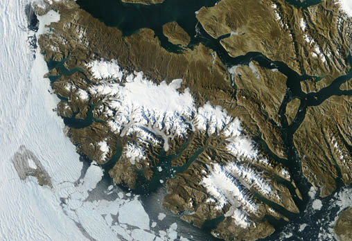
- Terra MODIS
- 26 June 2005
- 20:45 UTC
 Located within the Queen Elizabeth Islands region, Axel Heiberg
Island lies in the far northwest of the Canadian Arctic (it is the second most northerly island of the Canadian Arctic).
It is situated immediately west of its larger neighbour of Ellesmere Island (partially
visible on the right of the image), from which it is separated by the narrow Nansen Sound in the northeast and the even
narrower Eureka Sound in the east and southeast.
Located within the Queen Elizabeth Islands region, Axel Heiberg
Island lies in the far northwest of the Canadian Arctic (it is the second most northerly island of the Canadian Arctic).
It is situated immediately west of its larger neighbour of Ellesmere Island (partially
visible on the right of the image), from which it is separated by the narrow Nansen Sound in the northeast and the even
narrower Eureka Sound in the east and southeast.
At 37,200 km² in area, Axel Heiberg is the seventh largest of the Canadian Arctic islands. The island is mountainous, with the Princess Margaret Range forming an off-centre spine of the island that rises to a height of 2,210 m at Outlook Peak. The mountains, located on the western half of the island, run from the 650 m tall Svartevaeg Cliffs at the islands northern tip to the Stolz Peninsula at the mouth of Eureka Sound in the south. They present a rugged terrain of steep slopes and ice-fields. On the eastern side of the mountains the terrain is smoother consisting of hills, glacial terraces and sloping plateaus.
Much of the interior of the island is permanently covered in ice: by the Muller Ice Cap in the centre (over 600 m thick) and by the smaller Steacie Ice Cap in the south. In the upland regions of the far north of the island are a number of smaller ice caps — in all, a third of the island is covered by permanent ice and glaciers (around 11, 500 km²).
The coastline — particularly the west and south — is highly indented with large fjords and deep bays. Chief among these are Expedition Fiord (in the west) and Glacier Fiord (in the south), the latter receiving most of the glaciers that flow off the Steacie Ice Cap.


