
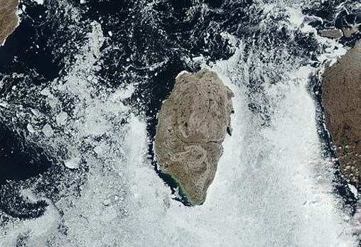
Mansel Island
- Aqua MODIS
- 05 July 2003
- 17:55 UTC
 Mansel Island sits at the northeastern entrance
into Hudson Bay, situated 58 km westwards from the northwestern coast of Quebec's Ungava Peninsula (visible at the right side of
the above image). The island's immediate island neighbours include Coats Island (115 km to the west), Southampton Island (150 km to the northwest) and Nottingham Island (120
km to the northeast).
Mansel Island sits at the northeastern entrance
into Hudson Bay, situated 58 km westwards from the northwestern coast of Quebec's Ungava Peninsula (visible at the right side of
the above image). The island's immediate island neighbours include Coats Island (115 km to the west), Southampton Island (150 km to the northwest) and Nottingham Island (120
km to the northeast).
At 3,180 km² in area, Mansel Island is the smallest of the three large islands (Mansel, Coats and Southampton) that form the northern boundary to Hudson Bay; the island measures 112 km in length and 48 km in width. The land is low-lying, consisting of a limestone-based plain averaging between 40 m and 80 m above sea level; maximum elevations of around 100 m are reached to the northwest of the Digger Lake region. The approximately 7 km long Digger Lake is visible as a dark strip running inland from the central east coast; it is one of several lakes and rivers that occupy a shallow valley feature (just discernable in the image) that cuts right across the island.
image: MODIS rapid response project at nasa/goddard space flight center.


