
Lougheed Island
- Terra MODIS
- 08 July 2003
- 03:15 UTC
 Lougheed Island is located in the high Arctic zone of the southwestern Queen Elizabeth Islands group. The island
occupies the centre of a semi-enclosed sea-like region — the Prince Gustaf Adolf Sea — formed by its larger
neighbours: Ellef Ringnes Island (68 km to the northeast, across the Maclean Strait), the
Bathurst Island group (51 km to the south, across the Desbarats Strait),
Melville Island (94 km to the southwest) and MacKenzie King Island
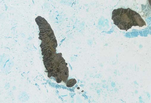
(95 km to the northeast). Its nearest neighbour is the small King Christian Island, 67 km
to the northeast (at top-right in the above image).
Lougheed Island is located in the high Arctic zone of the southwestern Queen Elizabeth Islands group. The island
occupies the centre of a semi-enclosed sea-like region — the Prince Gustaf Adolf Sea — formed by its larger
neighbours: Ellef Ringnes Island (68 km to the northeast, across the Maclean Strait), the
Bathurst Island group (51 km to the south, across the Desbarats Strait),
Melville Island (94 km to the southwest) and MacKenzie King Island
(95 km to the northeast). Its nearest neighbour is the small King Christian Island, 67 km
to the northeast (at top-right in the above image).
Lougheed Island is the largest of a small, linear, cluster of five islands — known as the Findlay Group. These include: Patterson Island (the southernmost member of the chain), Grosvenor Island, Edmund Walker Island (the largest after Lougheed Island) and Stupart Island (closest to Lougheed, but not readily visible in the above low-resolution image).
Lougheed Island (1,308 km²) is elongate in outline, measuring 82 km in length with a maximum width of 28 km in the south. The terrain is generally low throughout the island, rising from low a low-lying coastal belt to a hilly interior with average elevations between 60 m and 110 m.
image: MODIS rapid response project at nasa/goddard space flight center.


