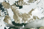
Devon Island

- Terra MODIS
- 08 July 2003
- 03:15 UTC
 Devon
Island is among the largest members of the Arctic Archipelago, forming part of the Queen Elizabeth Islands group. The
island is located northwards across the Lancaster Sound — itself forming the eastern portions of the North West
Passage — from Somerset Island and the Brodeur and
Borden peninsulas of northern Baffin Island; to the north,
the Jones Sound separates Devon Island from the southern reaches of Ellesmere Island (just
visible at the top-edge of the above image). To the east are located the open waters that comprise the northwestern limits
of the sea-like Baffin Bay. Also visible in this image is the smaller Cornwallis Island
(bottom-left).
Devon
Island is among the largest members of the Arctic Archipelago, forming part of the Queen Elizabeth Islands group. The
island is located northwards across the Lancaster Sound — itself forming the eastern portions of the North West
Passage — from Somerset Island and the Brodeur and
Borden peninsulas of northern Baffin Island; to the north,
the Jones Sound separates Devon Island from the southern reaches of Ellesmere Island (just
visible at the top-edge of the above image). To the east are located the open waters that comprise the northwestern limits
of the sea-like Baffin Bay. Also visible in this image is the smaller Cornwallis Island
(bottom-left).
At 55,247 km² in area, Devon Island ranks as the sixth largest island of Canadian territory with a maximum east to west length of 503 km and 289 km north to south. In overall appearance the island forms an inverted-"L" shape with the main mass of the island forming an east to west trending, rectangular-shaped, block that turns abruptly to the north at its western end. From the northwestern tip of this block emerges the large bulk of the Grinnell Peninsula.
Devon Island exhibits three broad geological zones that trend from east to west. The western end of the island (delineated approximately by a line running from Cape Sparbo on the north coast to Croker Bay on the south coast) comprises part of the Canadian Shield — and is largely covered by the Devon Island Ice Cap (see below). From Croker Bay westwards, to a line running southwest from Viks Fiord on the north to Dragleybeck Inlet on the south coast, terrain consists of an elevated plateau of between 300 and 400 m in height. This often deeply eroded terrain represents part of the Lancaster Plateau (also present on parts of southern Ellesmere Island and northeastern Baffin Island as well as on the mainland at the Boothia Peninsula). It is part of the Arctic Lowlands physiographic region and gently slopes downwards from north to south. North from this line, and including the Grinnell Peninsula, hilly terrain predominates.
Much of the eastern end of the island is buried beneath the snow and ice of the Devon Island Ice Cap. Covering an area of over 12,000 km², the ice cap forms a large dome containing some 3,980 km³ of ice, with a maximum thickness of 880 m. Stagnant ice formations extending to the west add a further 2,000 km² to its size. The highest elevations on Devon Island are found over the ice cap, where a maximum height above sea level of 1,921 m is reached.
Coastlines around the island are varied and include tall cliffs, sharp slopes, deep fjords (often glacier-filled in the west), lowlands and areas of beach. Offshore lie numerous small islands, the largest of which is Philpots Island located off the eastern end.
Devon Island presents a bleak and barren landscape that is typical of the polar desert environment. Flat, stony plains broken by shallow drainage channels typify much of the landscape — particularly in the central regions.
image: MODIS rapid response project at nasa/goddard space flight center