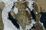
Prince of Wales Island

- Terra MODIS
- 31 July 2006
- 19:10 UTC
 Prince of Wales Island lies in the southern Arctic region. It is situated across the Peel Sound and the Franklin Strait
from Somerset Island and the Boothia Peninsula (which together form a near continuous barrier
on the eastern side). To the west across the wide McClintock Channel lie Victoria Island and
Stefansson Island. To the north across the the Barrow Strait (part of the larger Parry
Channel) are the High Arctic islands of the Queen Elizabeth group.
Prince of Wales Island lies in the southern Arctic region. It is situated across the Peel Sound and the Franklin Strait
from Somerset Island and the Boothia Peninsula (which together form a near continuous barrier
on the eastern side). To the west across the wide McClintock Channel lie Victoria Island and
Stefansson Island. To the north across the the Barrow Strait (part of the larger Parry
Channel) are the High Arctic islands of the Queen Elizabeth group.
At 33,339 km² in area Prince of Wales Island ranks as the tenth largest island of Canadian territory. Measuring around 310 km from north to south and 60 to 210 km from east to west the island has an approximately rectangular shape, with a coastline punctured by numerous headlands, peninsulas and bays. On the northwestern side the coast is cut deeply by the broad Ommanney Bay (ice-bound in the above image). On the eastern side the angled Browne Bay is protected by several islands — Prescott Island (412 km²), Pandora Island (142 km²), Vivian Island, Lock Island and Binstead Island. Off the northern coast, separated from the mainland by the Baring Channel, is the largest of the offshore islands — Russell Island (940 km²). The southern shore is split by the narrow channel that is formed by Guillemard Bay.
Terrain on the island can be broadly classified into three distinct zones. A low region is found in the southwest (light-coloured and lake-studded in the above image) where elevations are generally less than 100 m above sea level. Of the many rivers and lakes to be found in this region, Crooked Lake and Fisher Lake are the largest, the former draining into Browne Bay via the Dolphin River and the latter into Guillemard Bay via the Fisher River.
The lowland region of the southwest gives way to a more elevated zone in the east (darker-coloured in the above image) consisting of a flat to hilly plateau region with a limestone and sandstone bedrock, where elevations of between 100 and 250 m above sea level are the norm. A third zone in the east comprises a narrow strip of land at the easternmost extremities of the island (to the right of the dark band) containing the islands highest elevations, with peaks of over 300 m being common. The highest elevation is found at Hardy Dome, 5 km inland from Cape Hardy on the northeastern coast, where a height of 415 m is reached.
image: MODIS rapid response project at nasa/goddard space flight center.